Reports >
Aerospace And Defense
>
Aerial Imaging Market Report

Aerial Imaging Market Report
First published: 11 October 2024 | Last updated: 03 February 2026 | Report Code: aerial-imaging
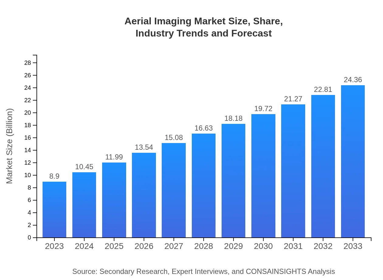
Aerial Imaging Market — USD 8.9 billion in 2023, Growing to USD 24.36B by 2033 at 10.2% CAGR
This report provides a comprehensive analysis of the Aerial Imaging market, including market size, trends, technological advancements, competitive landscape, and regional insights for the forecast period 2023-2033.
| Metric | Value |
|---|---|
| Study Period | 2023 - 2033 |
| 2023 Market Size | $8.90 Billion |
| CAGR (2023-2033) | 10.2% |
| 2033 Market Size | $24.36 Billion |
| Top Companies | GeoIQ, DroneDeploy, Pix4D, senseFly |
| Published Date | 11 October 2024 |
| Last Modified Date | 03 February 2026 |
Aerial Imaging Market Overview
Customize Aerial Imaging Market Report market research report
- ✔ Get in-depth analysis of Aerial Imaging market size, growth, and forecasts.
- ✔ Understand Aerial Imaging's regional dynamics and industry-specific trends.
- ✔ Identify potential applications, end-user demand, and growth segments in Aerial Imaging
What is the Market Size & CAGR of Aerial Imaging market in 2023?
Aerial Imaging Industry Analysis
Aerial Imaging Market Segmentation and Scope
Tell us your focus area and get a customized research report.
Aerial Imaging Market Analysis Report by Region
Europe Aerial Imaging Market Report:
The European market, starting at $2.82 billion in 2023 and projected to rise to $7.72 billion by 2033, benefits from stringent regulations fostering UAV use in sustainable urban development and environmental conservation initiatives.Asia Pacific Aerial Imaging Market Report:
In 2023, the Aerial Imaging market in the Asia Pacific is valued at $1.67 billion, projected to grow to $4.56 billion by 2033. The increase is propelled by rapid urbanization and the escalating demand for aerial imagery in agricultural precision, disaster management, and urban planning across the region.North America Aerial Imaging Market Report:
North America dominates the Aerial Imaging market with a size of $3.33 billion in 2023, forecasted to expand to $9.12 billion by 2033. The strong growth is driven by technological advancements, widespread adoption in various sectors, and substantial investments in aerial imaging technologies.South America Aerial Imaging Market Report:
South America shows a market size of $0.72 billion in 2023, expected to reach $1.96 billion by 2033. The growth is attributed to improving regulatory environments that promote drone use in agriculture and environmental monitoring.Middle East & Africa Aerial Imaging Market Report:
In the Middle East and Africa, the Aerial Imaging market is currently valued at $0.36 billion in 2023, expected to grow to $0.99 billion by 2033. Investments in infrastructure and urban development projects are driving the need for improved aerial imaging capabilities.Tell us your focus area and get a customized research report.
Aerial Imaging Market Analysis By Technology
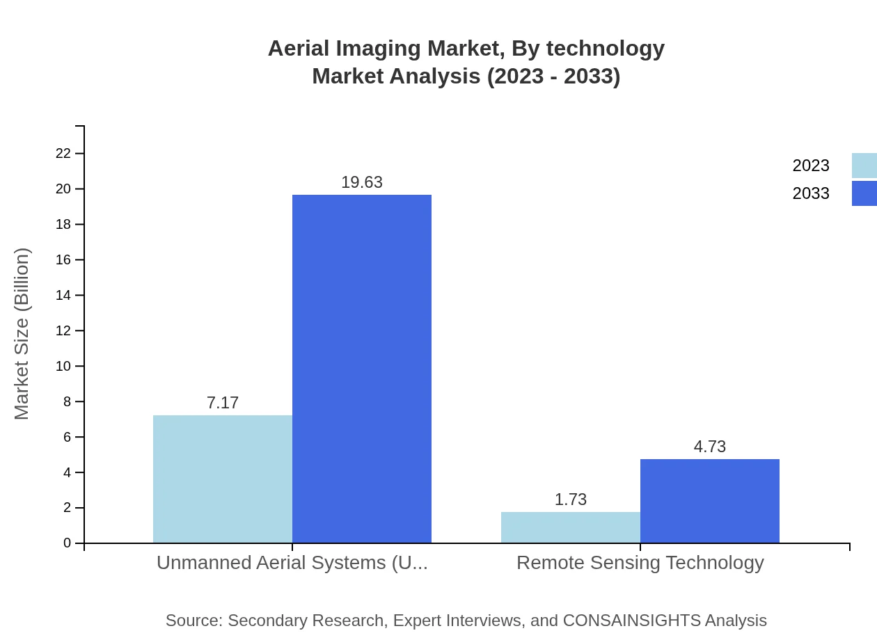
The Aerial Imaging market by technology highlights the UAS segment as a significant driver with a market size of $7.17 billion in 2023, anticipated to soar to $19.63 billion by 2033, demonstrating the growing reliance on drones for data collection. Remote sensing also plays a crucial role, expected to reach $4.73 billion by 2033, as industries leverage this technology for comprehensive environmental monitoring.
Aerial Imaging Market Analysis By Application

The application segment of the Aerial Imaging market reveals agriculture holding a strong share of the market, valued at $6.08 billion in 2023 and projected to grow to $16.64 billion by 2033, reflecting its essential role in enhancing crop management and yield assessment. Environmental monitoring also continues to gain attention, with market growth from $2.21 billion to $6.04 billion anticipated in the same period.
Aerial Imaging Market Analysis By Product Type
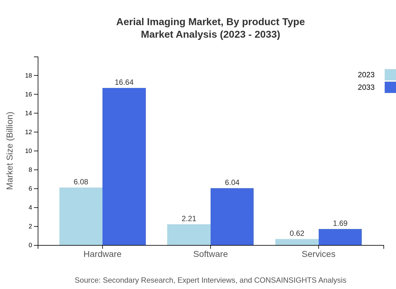
In the product category, hardware remains a major segment, expected to grow from $6.08 billion in 2023 to $16.64 billion by 2033. This segment encompasses imaging sensors, drones, and other imaging tools. Software solutions for data analysis are also significant, projected to increase from $2.21 billion to $6.04 billion, underscoring the importance of software in post-processing aerial images.
Aerial Imaging Market Analysis By End User
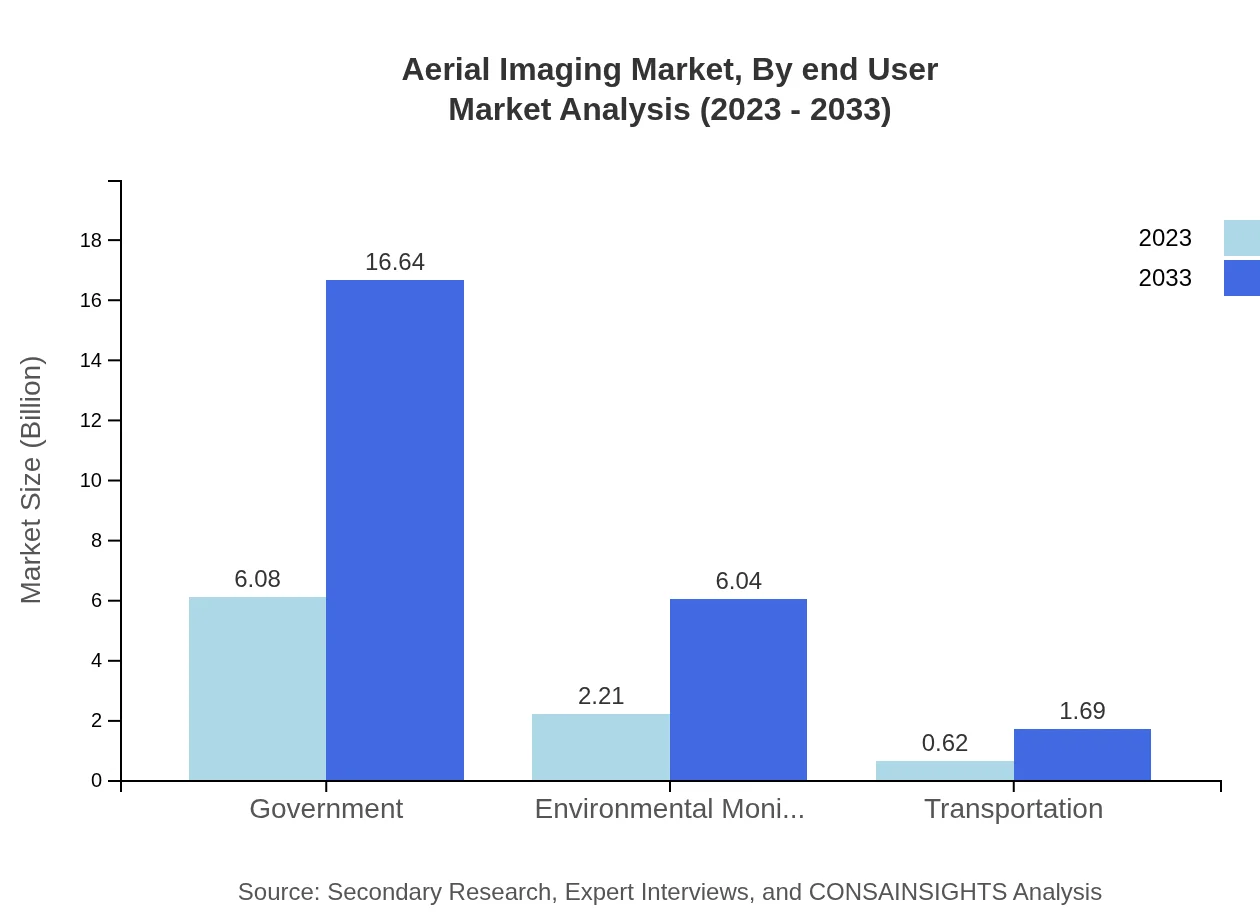
The end-user industry analysis highlights government applications commanding 68.3% of market share in 2023 and expected to maintain prominence by 2033. The construction and mining sectors are also significant, with an analysis showing growth from $2.21 billion, while energy and utilities applications continue to grow from $0.62 billion to $1.69 billion, highlighting the versatility of aerial imaging across diverse industries.
Aerial Imaging Market Trends and Future Forecast
Tell us your focus area and get a customized research report.
Global Market Leaders and Top Companies in Aerial Imaging Industry
GeoIQ:
GeoIQ is a leader in providing aerial imaging and geospatial analytics, combining drone technology with advanced data processing capabilities to enhance decision-making in agriculture and environmental monitoring.DroneDeploy:
DroneDeploy is a prominent cloud-based platform for drone mapping and aerial data analysis, known for its user-friendly solutions that assist in construction and agricultural inspection.Pix4D:
Pix4D specializes in photogrammetry software that processes images collected by drones, widely used for mapping in construction, agriculture, and surveying applications.senseFly:
senseFly provides fixed-wing drone solutions for professional mapping, enabling high-quality aerial imagery collection across several industries, including mining and construction.We're grateful to work with incredible clients.


FAQs
What is the market size of aerial Imaging?
The aerial-imaging market is projected to reach a size of approximately $8.9 billion by 2033, growing at a CAGR of 10.2%. This growth reflects increasing demand across industries for advanced imaging technologies.
What are the key market players or companies in this aerial Imaging industry?
Key market players in the aerial imaging industry include major companies that specialize in drone technology, satellite imaging, and geographic information systems. These companies are focusing on innovation to maintain competitive advantage and expand market presence.
What are the primary factors driving the growth in the aerial Imaging industry?
Growth in the aerial imaging industry is primarily driven by advancements in drone technology, rising applications in agriculture and environmental monitoring, and increasing demand for geographic data analysis across various sectors.
Which region is the fastest Growing in the aerial Imaging?
The fastest-growing region in the aerial imaging market is North America, projected to increase from $3.33 billion in 2023 to $9.12 billion by 2033. Europe and Asia Pacific also exhibit significant growth, driven by technological advancements.
Does ConsaInsights provide customized market report data for the aerial Imaging industry?
Yes, ConsaInsights offers customized market report data tailored to specific needs in the aerial-imaging industry. This allows clients to access relevant, actionable insights to inform strategic decisions.
What deliverables can I expect from this aerial Imaging market research project?
Deliverables from the aerial-imaging market research project include detailed market analysis reports, competitive landscape assessments, and forecasts covering market size, growth trends, and key segments.
What are the market trends of aerial Imaging?
Current market trends in aerial imaging include the integration of AI and machine learning for data analysis, increased use of unmanned aerial systems across sectors, and a growing emphasis on remote sensing technologies.