Consainsights logo
Background Image

Remote Sensing Satellites Market Report

Remote-Sensing Satellites Market by Product (Optical Satellites, Radar Satellites, Infrared Satellites), Application (Agriculture, Environmental Monitoring, Defense and Security, Urban Planning), Region – Analysis on Size, Share, Trends, COVID-19 Impact, Competitive Analysis, Growth Opportunities and Key Insights from 2023 to 2030.

01 Executive Summary

Remote Sensing Satellites Market Size & CAGR

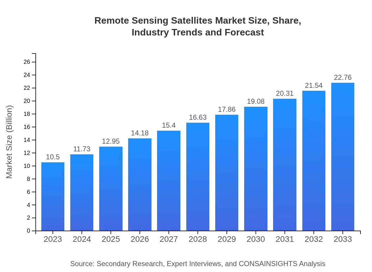
The global Remote Sensing Satellites market is projected to reach a market size of USD 10.5 billion by 2023, with a Compound Annual Growth Rate (CAGR) of 7.8% from 2023 to 2030. The forecast growth rate from 2023 to 2030 indicates a steady increase in the demand for remote sensing satellites across various industries.

COVID-19 Impact on the Remote Sensing Satellites Market

The COVID-19 pandemic has significantly impacted the Remote Sensing Satellites market, with disruptions in supply chains, project delays, and reduced investments in satellite technology. However, the pandemic has also highlighted the importance of remote sensing satellites in monitoring global events, natural disasters, and environmental changes. The market is expected to recover gradually as economies stabilize and demand for satellite imagery increases.

Remote Sensing Satellites Market Dynamics

The Remote Sensing Satellites market is driven by advancements in satellite technology, increasing demand for real-time data analytics, and growing applications in agriculture, defense, and environmental monitoring. However, security concerns, regulatory challenges, and high initial costs hinder market growth. The market is characterized by intense competition, rapid technological innovation, and strategic collaborations among key players.

Segments and Related Analysis of the Remote Sensing Satellites Market

The Remote Sensing Satellites market can be segmented based on technology, product, application, and end-user. Technologies include optical imaging, radar sensing, and LiDAR. Products range from satellite sensors to ground stations. Applications encompass agriculture, forestry, climate monitoring, and disaster management. End-users include government agencies, commercial enterprises, research institutions, and defense organizations.

Remote Sensing Satellites Market Analysis Report by Region

Asia Pacific Remote Sensing Satellites Market Report

The Asia Pacific region is a key market for remote sensing satellites, driven by investments in space technology, increasing demand for satellite imagery in agriculture and urban planning, and government initiatives for Earth observation. Countries like China, India, and Japan are investing heavily in satellite technology, creating opportunities for satellite manufacturers and service providers in the region.

South America Remote Sensing Satellites Market Report

South America presents significant growth potential for the Remote Sensing Satellites market, with applications in natural resource management, mining, and environmental monitoring. Countries like Brazil and Argentina are ramping up their satellite programs to address challenges related to deforestation, climate change, and disaster response. Collaboration with international space agencies and private sector partnerships are driving innovation in the region.

North America Remote Sensing Satellites Market Report

North America leads the global Remote Sensing Satellites market, with key players like SpaceX, NASA, and DigitalGlobe driving innovation in satellite technology. The region is characterized by a strong demand for satellite imagery in agriculture, defense, and environmental monitoring. Strategic partnerships between government agencies, commercial space companies, and research institutions propel market growth in North America.

Europe Remote Sensing Satellites Market Report

Europe is a prominent player in the Remote Sensing Satellites market, with countries like Germany, France, and the UK investing in satellite technology for civil and defense applications. The European Space Agency (ESA) and commercial satellite operators like Airbus and Thales Alenia Space are driving innovation in Earth observation and remote sensing. The region's focus on sustainability, climate change mitigation, and natural disaster response fuels the demand for remote sensing satellites.

Middle East and Africa Remote Sensing Satellites Market Report

The Middle East and Africa region are witnessing rapid growth in the Remote Sensing Satellites market, with applications in oil and gas exploration, urban planning, and infrastructure development. Countries like the UAE, Saudi Arabia, and South Africa are investing in satellite technology to address environmental challenges, monitor natural resources, and enhance national security. Public-private partnerships and collaborations with international space agencies drive innovation and market expansion in the region.

Remote Sensing Satellites Market Analysis Report by Technology

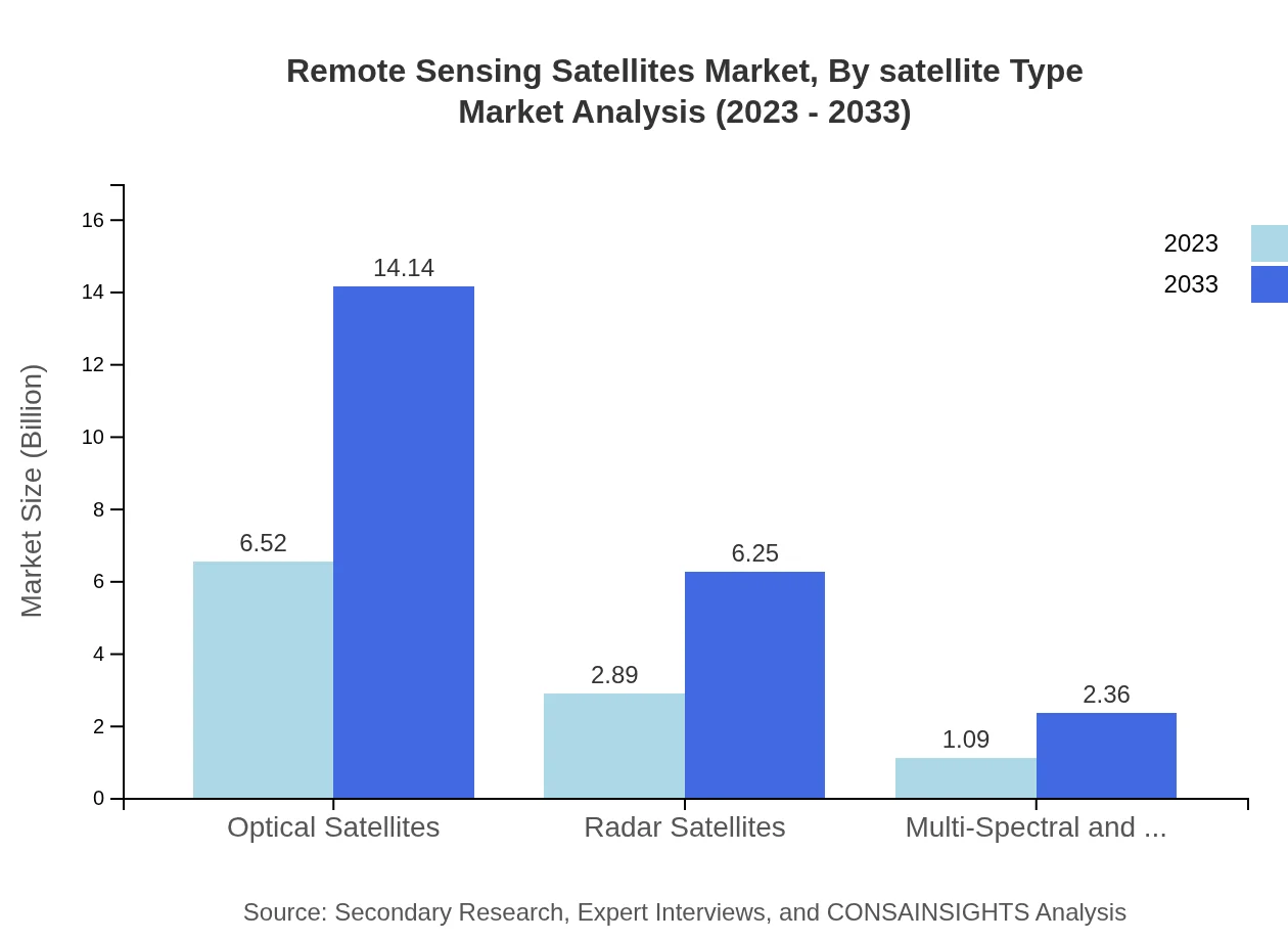
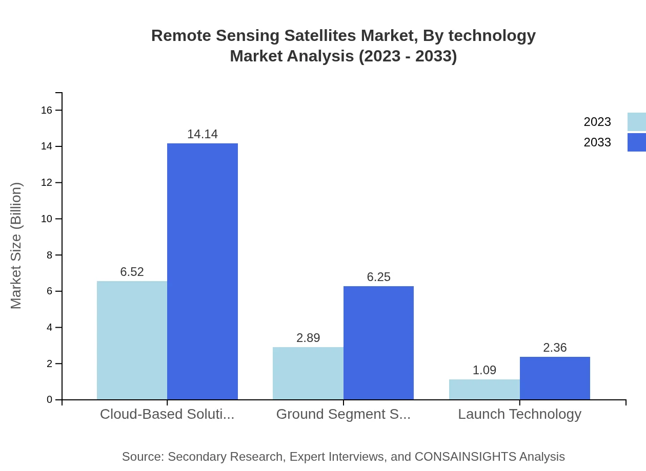
The Remote Sensing Satellites market can be analyzed based on different technologies such as optical imaging, radar sensing, LiDAR, and hyperspectral imaging. Each technology offers unique capabilities for capturing and analyzing Earth's surface features, supporting a wide range of applications in agriculture, forestry, climate monitoring, disaster response, and urban planning.

Remote Sensing Satellites Market Analysis Report by Product

Products in the Remote Sensing Satellites market include satellite sensors, ground stations, data processing software, and satellite communication systems. These products play a crucial role in capturing, transmitting, and analyzing satellite imagery for various applications in agriculture, defense, environmental monitoring, and disaster management.

Remote Sensing Satellites Market Analysis Report by Application

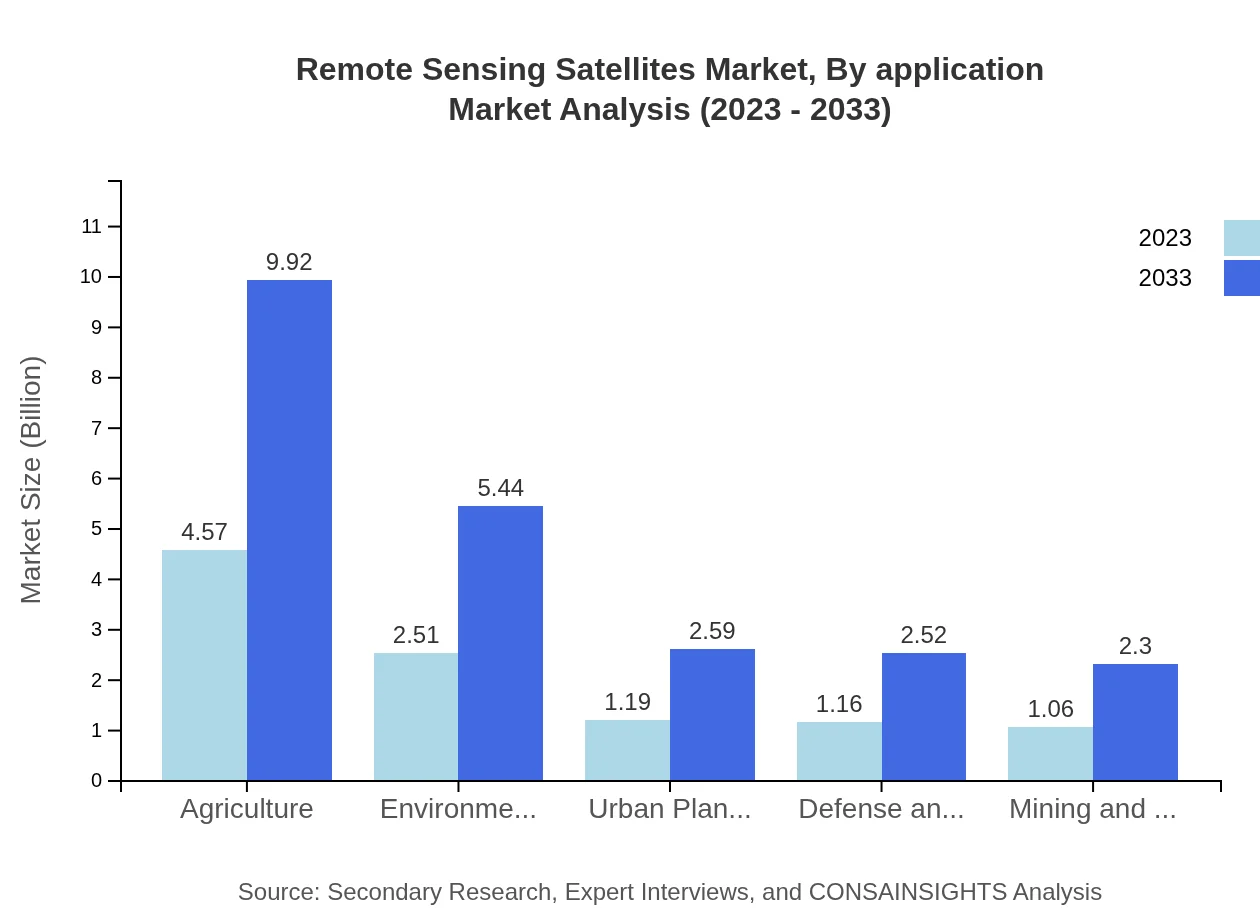
Applications of remote sensing satellites span across agriculture, forestry, climate monitoring, disaster management, urban planning, and defense. Satellite imagery and data analytics support decision-making processes in these sectors, providing valuable insights for sustainable development, resource management, and risk mitigation.

Remote Sensing Satellites Market Analysis Report by End-User

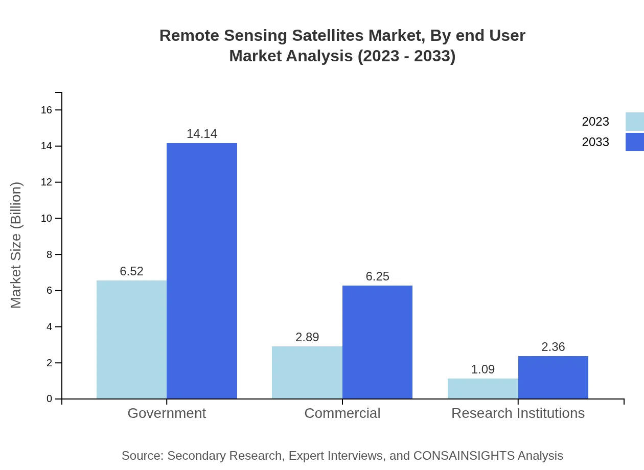
End-users of remote sensing satellites include government agencies, commercial enterprises, research institutions, defense organizations, and non-profit organizations. Each end-user segment leverages satellite technology for specific purposes, ranging from environmental monitoring to security surveillance and scientific research.

Key Growth Drivers and Key Market Players of Remote Sensing Satellites Market

The Remote Sensing Satellites market is driven by key growth drivers such as increasing demand for Earth observation data, advancements in satellite technology, rising investments in space exploration, and growing applications in agriculture, environmental monitoring, and disaster response. Key market players in the Remote Sensing Satellites market include:

  • Airbus
  • MDA Corporation
  • Ball Aerospace
  • Maxar Technologies
  • Thales Alenia Space

Remote Sensing Satellites Market Trends and Future Forecast

Emerging trends in the Remote Sensing Satellites market include the integration of artificial intelligence and machine learning, the development of small satellite constellations, the rise of commercial satellite operators, and the expansion of applications in precision agriculture, climate change monitoring, and smart cities. The future forecast for the Remote Sensing Satellites market predicts sustained growth driven by technological advancements, increasing adoption across industries, and the need for real-time Earth observation data.

Recent Happenings in the Remote Sensing Satellites Market

Recent developments in the Remote Sensing Satellites market include:

  • Airbus launched the Amos-18 satellite for environmental monitoring and disaster response.
  • MDA Corporation acquired a stake in a new satellite imaging startup focused on climate change monitoring.
  • Ball Aerospace announced a collaboration with NASA to develop advanced satellite technology for space exploration.
  • Maxar Technologies launched a new satellite imagery platform for commercial and government customers.
  • Thales Alenia Space partnered with a European space agency to develop cutting-edge satellite communication systems.

02 Research Methodology

Our research methodology entails an ideal mixture of primary and secondary initiatives. Key steps involved in the process are listed below:

  • Step 1. Data collection and Triangulation

    This stage involves gathering market data from various sources to ensure accuracy and comprehensiveness.

  • Step 2. Primary and Secondary Data Research

    Conducting in-depth research using both primary data (interviews, surveys) and secondary data (reports, articles) to gather relevant information.

  • Step 3. Data analysis

    Analyzing and interpreting the collected data to identify patterns, trends, and insights that can inform decision-making.

  • Step 4. Data sizing and forecasting

    Estimating the size of the market and forecasting future trends based on the analyzed data to guide strategic planning.

  • Step 5. Expert analysis and data verification

    Engaging subject matter experts to review and verify the accuracy and reliability of the data and findings.

  • Step 6. Data visualization

    Creating visual representations such as charts and graphs to effectively communicate the data findings to stakeholders.

  • Step 7. Reporting

    Compiling a comprehensive report that presents the research findings, insights, and recommendations in a clear and concise manner.

Data collection and Triangulation

The foundation is meticulous data gathering from multiple primary and secondary sources through interviews, surveys, industry databases, and publications. We critically triangulate these data points, cross-verifying and correlating findings to ensure comprehensiveness and accuracy.

Primary and Secondary Data Research

Our approach combines robust primary research discussion with industry experts and an exhaustive study of secondary data sources. A comprehensive analysis of published information from credible databases, journals, and market research reports complements direct interactions with industry stakeholders and key opinion leaders.

Data analysis

With a wealth of data at our disposal, our seasoned analysts meticulously examine and interpret the findings. Leveraging advanced analytical tools and techniques, we identify trends, patterns, and correlations, separating signal from noise to uncover profound insights that shed light on market realities.

Data sizing and forecasting

Armed with a profound understanding of market dynamics, our specialists employ robust statistical models and proprietary algorithms to size markets accurately. We go a step further, harnessing our predictive capabilities to forecast future trajectories, empowering clients with foresight for informed decision-making.

Expert analysis and data verification

Our research findings undergo a rigorous review by a panel of subject matter experts who lend their deep industry knowledge. This critical analysis ensures our insights are comprehensive and aligned with real-world dynamics. We also meticulously verify each data point, leaving no stone unturned in our pursuit of accuracy.

Data visualization

To unlock the true potential of our research, we employ powerful data visualization techniques. Our analysts transform complex datasets into intuitive visuals, including charts, graphs, and interactive dashboards. This approach facilitates seamless communication of key insights, enabling stakeholders to comprehend market intricacies at a glance.

Reporting

The final step is providing detailed reports that combine our in-depth analysis with practical advice. Our reports are designed to give clients a competitive edge by clearly explaining market complexities and highlighting emerging opportunities they can take advantage of.

03 Market Overview

Market Definition and Scope
Market Segmentation
Currency
Forecast
Assumptions

Market Definition and Scope

The remote sensing satellites market encompasses the design, manufacture, and deployment of satellites that are equipped with technology to capture data about the Earth’s surface and atmosphere. These satellites are vital for various applications such as agriculture, forestry, land use management, and disaster response. The scope of the remote sensing satellites market includes both commercial and government satellites that are utilized for Earth observation and data collection tasks. With growing concerns over climate change, national security, and resource management, the demand for remote sensing satellites has witnessed a significant increase in recent years.

This market is not only pivotal for environmental monitoring but also significantly contributes to advancements in urban planning, transportation, and natural resource management. The integration of remote sensing data with other technologies like GIS (Geographic Information Systems) enhances the quality and applicability of the insights gained from satellite imagery. Moreover, the trend towards miniaturization has led to the launch of smaller, more cost-effective satellites, which have expanded the landscape of remote sensing capabilities. Ongoing advancements in satellite technology, including higher resolution imaging and faster data transmission, continue to propel market growth and innovation.

As new players enter the market, competition intensifies, leading to improvements in technology and reductions in costs, which will further democratize access to satellite data. The evolution of satellite constellations and the emergence of small satellites, or SmallSats, play crucial roles in the future of the remote sensing industry by enabling real-time data processing and enhanced collaborative capabilities among different satellite operators and end-users. A considerable focus on sustainability and eco-friendly practices is also shaping the development within the remote sensing sector.

Industry stakeholders must remain aware of regulatory frameworks and licensing requirements that govern satellite launches and operations. The remote sensing satellites market is subject to international treaties, particularly in relation to the sharing of information derived from satellite data, which can affect operational capabilities and commercial viability. Additionally, partnerships between governmental space agencies and private companies are increasingly commonplace, offering pathways toward innovation and expanded service offerings, as well as ensuring compliance with national and international regulations regarding space exploration and technology usage.

In summary, the remote sensing satellites market stands at the intersection of technology innovation and valuable applications across multiple sectors. As the market evolves, it will continue to play a critical role in enhancing our understanding of planetary changes, improving decision-making processes, and delivering timely and actionable insights for organizations across the globe.

Market Segmentation

The remote sensing satellites market can be segmented based on various criteria, including type, application, and end-user. Type segmentation primarily categorizes the satellites into two main classes: Earth observation satellites and meteorological satellites. Earth observation satellites focus on capturing data for land and resource monitoring, while meteorological satellites are dedicated to weather forecasting and climatology. This distinction is crucial as it highlights the varying technologies and data collection methodologies employed within the sector, influencing both market dynamics and technological advancements.

Application segmentation further categorizes the market into areas such as agriculture, environmental monitoring, urban planning, defense and intelligence, disaster management, and transportation. For instance, the agriculture segment involves the use of satellite imagery for crop monitoring, yield prediction, and soil analysis, which contributes significantly to enhancing agricultural productivity and sustainability. Similarly, environmental monitoring applications utilize remote sensing data to track changes in ecosystems, deforestation rates, and climate phenomena, which are essential for formulating environmental policies and management strategies.

End-user segmentation identifies primary consumers of remote sensing satellite data, which include government agencies, commercial enterprises, academic institutions, and non-governmental organizations (NGOs). Government agencies often leverage satellite data for national security, surveillance, and resource management, while commercial enterprises utilize the information for data analytics, market research, and operational efficiencies. Academic institutions engage with remote sensing data for research and educational purposes, contributing to knowledge advancement in various fields, while NGOs utilize such data to support humanitarian efforts and advocate for environmental protection.

Geography also plays a significant role in market segmentation, as different regions exhibit varying levels of technological adoption, demand for satellite services, and regulatory frameworks. North America and Europe currently dominate the remote sensing satellites market, driven largely by significant investments and advancements in satellite technology. Meanwhile, Asia-Pacific is emerging as a rapidly growing market due to increasing collaborations in space technologies and rising applications of remote sensing data across various sectors. This geographic insight helps industry players tailor their strategies to meet the specific demands and conditions of each market.

Overall, the segmentation of the remote sensing satellites market provides invaluable insights that can drive strategic decisions for manufacturers and service providers looking to navigate this dynamic industry landscape. By understanding the unique needs and preferences of each segment, stakeholders can effectively align their offerings with market demands and capitalize on growth opportunities within the sector.

Currency

The remote sensing satellites market is typically analyzed in terms of monetary value, which can vary significantly depending on the specific segments and applications being assessed. The currency used for market valuation often includes prominent global currencies such as the United States Dollar (USD), Euro (EUR), and British Pound (GBP). When preparing market reports and forecasts, it is crucial to standardize the currency to maintain accuracy and consistency in data interpretation.

Given the international nature of the remote sensing industry, it is common for stakeholders to convert financial estimates into widely accepted currencies to facilitate easy comparison and analysis across different regions. This standardization is especially critical when evaluating market size, revenue growth, investments, and other financial metrics, ensuring that variations in local currencies and economic conditions are adequately accounted for in market assessments.

Furthermore, fluctuations in currency exchange rates can have a significant impact on the profitability of satellite manufacturers and service providers operating internationally. Companies engaged in cross-border transactions must consistently monitor currency trends to hedge against potential losses and ensure the financial viability of their operations. This awareness becomes even more pertinent for businesses that import components or services from abroad, as costs may be directly influenced by foreign currency valuations.

Ultimately, clear understanding and management of currency dynamics are essential for stakeholders in the remote sensing satellites market. Effective currency risk management strategies, including the use of financial instruments and hedging techniques, can enhance operational stability and profitability while also strengthening competitive positioning in the marketplace.

In conclusion, a thorough analysis of currency considerations is integral for evaluating the remote sensing satellites market. By recognizing the importance of financial conversions and the implications of exchange rate fluctuations on market health, industry players can make informed decisions that drive success and sustainability in their operations.

Forecast

The forecast for the remote sensing satellites market indicates robust growth in the coming years, driven by increasing demand for satellite-based data across various applications. Industry analysts project that advancements in satellite technology, such as improved imaging capabilities, faster data acquisition, and enhanced data processing techniques, will significantly augment market performance. The uptick in investments by both government and commercial sectors signals a strong outlook as stakeholders recognize the value of remote sensing data for critical decision-making processes.

The global market is expected to witness significant expansion as more countries develop their own satellite programs, aiming to enhance national security, natural resource management, and environmental monitoring. This growing trend of investment will further intensify competition within the remote sensing sector, encouraging innovation and subsequently driving the affordability and accessibility of satellite data services.

Moreover, the integration of Artificial Intelligence (AI) and machine learning technologies into remote sensing practices is predicted to revolutionize data processing and analysis methodologies. These advancements enable rapid analytics and improved decision-making capabilities, allowing organizations and governments to respond effectively to emergent situations and resource allocation needs, ultimately enhancing the value derived from satellite operations.

Regional forecasts suggest that while North America and Europe will continue to dominate the market, significant growth is anticipated in the Asia-Pacific region. The increased collaboration among private and public entities in advancing satellite technologies is expected to transform the dynamics of the market, with emerging economies investing in satellite infrastructure to leverage remote sensing capabilities for their developmental goals.

In summary, the future of the remote sensing satellites market is bright, with anticipated growth fostered by technological advancements, increased investments, and a growing array of applications. As stakeholders adapt to the evolving landscape of remote sensing, they will need to strategically position themselves to harness the potential these developments offer for enhanced operational efficiencies and competitive advantage in the marketplace.

Assumptions

The analysis of the remote sensing satellites market is grounded in several key assumptions that shape understanding of the industry's dynamics. One primary assumption is that continuous technological advancements will drive improvements in satellite capabilities, leading to increased demand for remote sensing applications. As the technology behind satellite systems evolves, it is anticipated that the quality and quantity of data provided will become more precise, enhancing the overall value of satellite applications in various sectors.

Another critical assumption involves the willingness of governments and enterprises to invest in satellite technology and data services. Investment is generally expected to grow based on the recognized importance of satellite data in addressing global challenges such as climate change, urbanization, and natural disasters. This growing recognition will serve as a catalyst for both public and private sector funding initiatives, aimed at fostering research and development in remote sensing technologies.

Additionally, there is an assumption regarding the continued expansion of international collaborations in space exploration and remote sensing initiatives. As countries partner together on satellite missions, shared data, and technological exchange, there will be a more robust flow of information across borders. This collaborative effort is expected to generate synergies that enhance the capabilities of participating nations and expand market opportunities for satellite operators and service providers.

Economic stability is another underlying assumption that impacts market projections. Should global economic conditions remain favorable with sustainable growth, the remote sensing satellites market is expected to flourish. Conversely, significant economic downturns or geopolitical tensions could adversely affect investments and project implementations in the sector, leading to projected market slowdowns.

In conclusion, these assumptions play a pivotal role in shaping the market dynamics of the remote sensing satellites industry. Stakeholders must remain cognizant of these foundational elements while navigating their strategic initiatives, ensuring heeding the inherent uncertainties of the market and adjusting plans to capitalize on emerging opportunities as they arise.

04 Market Dynamics

Market Drivers
Market Restraints
Market Opportunities
Market Challenges

Market Drivers

The demand for remote sensing satellites is primarily driven by the increasing need for accurate and timely data in various sectors such as agriculture, forestry, and environmental monitoring. These satellites provide crucial insights that help in optimizing resource management, improving crop yields, and monitoring deforestation. The advancements in satellite technologies also contribute to this growth, allowing for higher resolution imagery and real-time data transmission, enhancing decision-making processes across different industries.

Governments around the world are increasingly investing in satellite launches and related technologies, recognizing the strategic importance of remote sensing capabilities for national security, climate monitoring, and disaster management. Such investments are aimed at enhancing surveillance and reconnaissance to safeguard national interests while also supporting global initiatives to combat climate change. This governmental support further propels the growth of the market by creating a robust infrastructure for satellite deployment.

The proliferation of smart farming practices, driven by the need for sustainable agricultural practices, is another significant driver. Farmers increasingly rely on satellite data to monitor crop health, soil conditions, and weather patterns, allowing for precision agriculture that maximizes yield while minimizing waste and environmental impact. This shift towards smart farming is expected to lead to more substantial investments in remote sensing technologies, thereby driving market growth.

Moreover, the integration of remote sensing satellite data with advanced analytical tools and artificial intelligence is transforming the way organizations operate. This technological synergy allows for better data interpretation, enabling businesses to make informed decisions based on real-time and predictive analytics. The increased accessibility of satellite data through cloud platforms is also a key driver, allowing even small-scale enterprises to leverage sophisticated remote sensing technologies.

Lastly, the ongoing global challenges such as climate change, natural disasters, and urbanization necessitate constant monitoring of environmental changes. Remote sensing satellites play a pivotal role in tracking these developments, providing authorities with necessary data to formulate effective strategies for disaster resilience, urban planning, and sustainable development. As such, the market is poised for growth as the importance of remote sensing continues to gain traction across various domains.

Market Restraints

Despite the promising growth of the remote sensing satellites market, several factors inhibit its expansion. Chief among these restraints is the high cost associated with the design, manufacturing, and launching of satellites. The initial investment can be prohibitive for many organizations, especially smaller ones or startups, which may lack the financial resources to enter the market. This high capital requirement limits the number of players in the market and can stifle innovation.

Additionally, regulatory challenges can pose significant barriers to the market. The launch and operation of remote sensing satellites are subject to stringent government regulations and compliance requirements. Differing national policies and international treaties regarding satellite imagery and data usage complicate the landscape, potentially hindering effective collaboration between countries and limiting access to critical data.

Another significant constraint is the vulnerability of satellites to various threats, including cyberattacks, space debris, and unfavorable space weather. The risks associated with satellite operation can deter stakeholders from investing in this technology, as potential downtimes and damages may result in substantial financial losses. As the number of satellites increases, the collision risk with space debris also escalates, making the operational environment increasingly hazardous.

The technology lifecycle of remote sensing satellites can also be a challenge. As satellite technology evolves rapidly, there is a constant need for upgrades and replacements to keep pace with advancements. Organizations may find it difficult to continuously invest in newer technologies and ensure their existing satellite capabilities remain relevant. This technological obsolescence may lead to decreased competitiveness and potential market exit for certain players.

Finally, the limitation of data resolution and coverage from certain remote sensing satellites can impact their utility in specific applications. Lower quality or less frequent imagery may not meet the increasingly sophisticated demands of end-user applications, thereby leading to dissatisfaction and reduced adoption rates. These technical limitations create a challenging environment for remote sensing satellite solutions in fulfilling their intended purposes efficiently.

Market Opportunities

The remote sensing satellites market is set to harness numerous opportunities, especially with the focus on innovative technologies and applications. One of the most promising opportunities lies in the increasing demand for high-resolution satellite imagery. Industries such as urban planning, disaster management, and infrastructural development seek precise data to aid decision-making processes. This demand encourages satellite manufacturers and service providers to innovate and develop more sophisticated satellites capable of capturing fine details.

Moreover, the continuous expansion of application areas for remote sensing data, particularly in emerging markets, presents substantial growth opportunities. For instance, developing regions are increasingly adopting remote sensing technology for agriculture, land-use planning, and environmental monitoring. This is driven by the need for sustainable practices and efficient resource management. As these markets open up, stakeholders have the chance to establish themselves in new regions and diversify their offerings.

Advancements in machine learning and artificial intelligence are also providing fertile ground for market growth. By integrating AI algorithms with remote sensing data analysis, organizations can enhance their data processing capabilities, yielding better insights and enabling predictive analytics. This technological integration equips businesses to offer more refined services tailored to specific client needs, ultimately improving competitiveness in the marketplace.

Furthermore, partnerships and collaborations between governments, private sector entities, and research institutions can foster innovation and facilitate joint developments in remote sensing technology. Such collaborative efforts could lead to shared resources and knowledge exchange, resulting in the acceleration of satellite development and deployment. These partnerships can also be instrumental in expanding market reach and improving the accessibility of remote sensing services globally.

Additionally, the rising awareness regarding climate change and environmental protection initiatives propels the utilization of remote sensing satellites for monitoring greenhouse gas emissions, deforestation, and biodiversity. Governments and organizations are increasingly employing satellite data to support their policies and initiatives regarding sustainability. This trend not only creates market opportunities but also fulfills a societal need for more responsible environmental stewardship.

Market Challenges

The remote sensing satellites market faces several obstacles that could hamper its growth. One of the primary challenges is the rapid technological evolution of satellite components. Staying abreast of cutting-edge technologies necessitates significant investment in research and development, leading to financial strain for companies, especially those that lack the scale to absorb these costs. Smaller organizations could find it difficult to compete with more prominent players that have dedicated resources for innovation.

Another challenge lies in the complex nature of satellite data interpretation. The data generated by remote sensing satellites can be vast and intricate, making it challenging for end-users to derive actionable insights. There exists a considerable skills gap, as organizations struggle to find qualified personnel who can analyze and interpret satellite data effectively. This skills shortage may limit the market's ability to fully harness its technological potential.

The global supply chain disruptions that have been witnessed recently pose a significant challenge as well. The manufacturing of satellites relies on a variety of components sourced from different global regions. Any disruption can lead to delays and increased costs, which can, in turn, push back project timelines. Such unpredictability can make long-term planning difficult for organizations looking to invest in satellite technology.

Moreover, the environmental concerns associated with satellite launches and debris management cannot be overlooked. As the number of satellites in orbit increases, so does the risk of space debris, which poses a threat to both existing satellites and ground infrastructure. The management of space debris and adherence to environmental commitments not only generates regulatory scrutiny but also demands comprehensive strategies that require additional resources.

Lastly, the competitive landscape in the remote sensing satellites market is intensifying, with many entrants vying for market share. This growing competition pressures companies to reduce prices or increase innovation efforts continuously. As a result, businesses may struggle to maintain profit margins, leading to potential market instability and challenges for sustainable growth.

06 Regulatory Landscape

Overview of Regulatory Framework
Impact of Regulatory Policies on Market Growth

Overview of Regulatory Framework

The regulatory framework for remote sensing satellites has evolved significantly over the last few decades. Various international treaties, national regulations, and industry standards shape the operations of these satellites. A key component of this framework is the Outer Space Treaty of 1967, which establishes the principal tenets of international space law, including the use of outer space for peaceful purposes and the responsibility of nations for their space activities.

In addition to international treaties, many countries have established their own regulations governing remote sensing operations. For example, the United States has implemented a regulatory environment where the Department of Commerce oversees commercial remote sensing satellite licenses. This framework ensures that satellite operators comply with national security, foreign policy, and public safety objectives while promoting commercial innovation.

Additionally, the role of organizations such as the National Oceanic and Atmospheric Administration (NOAA) in the U.S. highlights how specific agencies can influence the regulatory landscape by monitoring compliance with licensing terms. NOAA's regulations focus on data accuracy, processing, and distribution, ensuring that the data collected from satellites adheres to established standards.

Countries around the globe also face unique challenges in creating robust regulatory frameworks for remote sensing operations. For instance, developing nations often struggle with the technological and financial constraints necessary to establish comprehensive oversight. As remote sensing technology becomes more accessible, these nations may find it difficult to effectively manage and govern satellite operations, potentially leading to misuse of satellite data.

The increasing prevalence of satellite constellations and the rise of private sector participation in remote sensing have further complicated the regulatory landscape. As the number of satellites in orbit grows, national and international bodies must work collaboratively to draft policies that ensure safe and responsible satellite operations. This often involves negotiations between various stakeholders, including private companies, government entities, and international organizations.

Impact of Regulatory Policies on Market Growth

Regulatory policies have a profound impact on the growth trajectory of the remote sensing satellite market. A favorable regulatory environment can stimulate investment, innovation, and expansion of services. Conversely, overly burdensome or unclear regulations can stifle market growth and deter new entrants. For instance, countries with streamlined licensing processes and transparent regulations tend to attract more investment in their satellite industries.

The role of regulations in ensuring national security cannot be overstated. Governments are increasingly aware of the potential risks associated with satellite data, particularly in areas concerning defense and critical infrastructure. As a result, policies aimed at protecting sensitive information can result in more cautious approaches to data sharing, which may inadvertently slow the pace of commercial growth in the sector.

Furthermore, international cooperation plays a critical role in shaping market growth. Harmonized regulations across different jurisdictions can promote cross-border data sharing and collaboration among satellite operators. This, in turn, facilitates a more competitive environment, allowing businesses to innovate and provide new services to their customers without the added complexities of navigating disparate regulatory frameworks.

The advent of new technologies, such as small satellites and CubeSats, has also influenced the regulatory landscape. These innovations often challenge existing regulations due to their unique operational characteristics and low-cost deployment models. As a result, regulatory bodies must adapt and evolve their policies to accommodate these changes, ensuring that they promote growth while maintaining safety and compliance.

Ultimately, the interaction between regulatory policies and market growth is a dynamic process. Regulators must recognize the balance between ensuring public safety and fostering economic development. A proactive approach in revising regulations based on market trends and technological advancements is essential to promote a thriving remote sensing satellite industry.

07 Impact of COVID-19 on the Artificial Intelligence Market

Short-term and Long-term Implications
Shift in Market Dynamics and Consumer Behavior

Short-term and Long-term Implications

The COVID-19 pandemic has had a profound impact on various sectors of the economy, with the remote sensing satellites market not being an exception. In the immediate aftermath of the pandemic, there was a noticeable dip in satellite launches and operations as countries went into lockdown, creating logistical challenges. The short-term implications included delays in the deployment of new satellites, reduced spending on satellite technology due to budget constraints, and a slowdown in the progress of ongoing projects.

However, as countries adapted to the new normal and remote working became prevalent, the demand for satellite data soared. In the short term, businesses in sectors such as agriculture, urban planning, and environmental monitoring rapidly adopted remote sensing technologies to maintain operations, leading to a recovery in market activity. This surge in demand for remote sensing data highlighted the technology's critical role in providing real-time information for decision-making amidst uncertainty.

Long-term implications are likely to be shaped by this shift in demand and awareness of the capabilities that remote sensing technology offers. Governments and organizations may increase their investment in satellite infrastructure, leading to a more resilient and robust market. Furthermore, partnerships and collaborations between private companies and governmental agencies may increase as stakeholders seek to leverage satellite data for various societal challenges, such as climate change, public health, and disaster management.

As we progress, the expectation for sustainable global development will drive the long-term investments in remote sensing satellites. Early adopters during the pandemic may establish themselves as market leaders, influencing future trends and strategies. Overall, the industry is likely to emerge more agile, with innovative solutions and applications that cater to an evolving marketplace.

In conclusion, while the immediate effects of COVID-19 led to difficulties and disruptions within the remote sensing satellites market, the long-term outlook appears promising due to increased recognition of the importance of satellite data. This duality shall define the trajectory of market growth in the coming years.

Shift in Market Dynamics and Consumer Behavior

The pandemic has significantly shifted both market dynamics and consumer behavior within the remote sensing satellites landscape. Initially marked by interruptions in operations, the market began to adapt quickly to the rapidly changing environment. One of the most notable shifts was the realization by stakeholders of the critical importance of satellite data in ensuring continuity of operations across various sectors. Organizations realized that traditional ground-based data collection methods posed various risks, leading to an increased reliance on satellite technology.

In terms of consumer behavior, there has been a marked shift towards more analytical and data-driven decision-making processes. As businesses scrambled to understand patterns and changes in their environment during the pandemic, the utility of satellite data became evident. Industries such as agriculture and forestry leveraged remote sensing technologies to monitor crop health, assess deforestation, and optimize resource allocation, demonstrating a pivot towards adopting predictive analytics.

This push towards a more data-centric framework has resulted in increased investments from private and public sectors in remote sensing technologies. The consumers of satellite data are now more diverse, encompassing a broader range of sectors including urban development, disaster response, and climate change monitoring. These new users bring fresh perspectives on the applications of remote sensing, stimulating innovative product offerings and services tailored to specific needs.

Moreover, the shift towards remote working has also impacted the market by changing the way in which services are delivered and consumed. Organizations have developed new capabilities to process and analyze satellite data remotely, fostering an environment where geographic location is less relevant for collaboration. This opens the door for niche players in the market, enabling them to provide specialized services without being limited by traditional geographic constraints.

In conclusion, the COVID-19 pandemic has catalyzed a shift in market dynamics and consumer behavior in the remote sensing satellites market, emphasizing a growing need for reliable, data-driven insights. The acceleration towards embracing satellite technology across various sectors has set the stage for a more diversified and innovative future in remote sensing applications.

08 Porter's Five Forces Analysis

Bargaining Power of Suppliers
Bargaining Power of Buyers
Threat of New Entrants
Threat of Substitutes
Competitive Rivalry

Bargaining Power of Suppliers

The bargaining power of suppliers in the remote sensing satellites market is a crucial factor that shapes the industry dynamics. Suppliers in this sector primarily provide critical components such as satellite hardware, software, and technical services needed for the design and manufacturing of satellites. The degree of supplier power can have significant implications on pricing, quality, and the overall production timeline for satellite manufacturers.

One key aspect that influences the bargaining power of suppliers is the level of specialization required for the components. Many suppliers produce highly specialized technology – for example, advanced sensors or imaging equipment – that is unique to the remote sensing sector. This specialization can increase supplier power, as manufacturers often have limited alternatives for these critical components, allowing suppliers to set higher prices and demand better terms.

Another factor is the number of suppliers available in the market. If the number of suppliers is low, or if notable suppliers dominate the market, they can exert a higher degree of control. This concentration leads to an imbalance in negotiation power, allowing these suppliers to dictate terms. Conversely, if the market consists of a larger base of suppliers, the bargaining power diminishes, providing manufacturers with more leverage to negotiate costs and drive innovation.

The technology lifecycle also plays a role in supplier power. As the remote sensing sector becomes more technology-driven, suppliers who develop cutting-edge technologies may hold more power due to their unique offerings. Manufacturers who rely heavily on the latest advancements will find themselves at the mercy of these suppliers, which further enhances the bargaining power they possess.

Lastly, the potential for vertical integration presents an opportunity for satellite manufacturers to reduce supplier power by developing in-house capabilities. Companies that make investments in research and development to create their own technology may significantly decrease their reliance on external suppliers, ultimately leading to lower costs and greater control over their product offerings.

Bargaining Power of Buyers

The bargaining power of buyers is an essential force that impacts pricing and profitability in the remote sensing satellites market. Buyers in this context include not only government agencies and commercial enterprises that utilize satellite data, but also research institutions and non-governmental organizations (NGOs). The nature of the buyer base significantly influences the ability of satellite manufacturers to command prices and the terms of service.

One of the main elements affecting buyer power is the availability of alternative sources of satellite data. If buyers can easily obtain comparable data from different providers, their bargaining power increases. They gain leverage to negotiate prices down as satellite manufacturers must compete not just on quality, but also on pricing. Moreover, as technology improves and more players enter the market, this trend is likely to continue, aggravating competition between satellite data providers.

Furthermore, the specificity of the needs of buyers can also dictate their bargaining power. Buyers with specialized requirements such as unique imaging capabilities or real-time data may have less power, as not every satellite manufacturer can cater to those needs effectively. However, for more general data needs, buyers can easily shift their business between providers, thus enhancing their negotiation strength.

Volume of purchase represents another critical aspect of buyer power. Large organizations, such as government agencies, often make bulk purchases which gives them a firmer stance in price negotiations. This leverage can result in favorable pricing, extended service agreements, and improvements to overall product offerings, thereby squeezing profit margins for satellite manufacturers.

Lastly, the overall economic environment can impact buyer power. In times of economic downturn, buyers may seek to cut costs and exercise more power to negotiate better terms from satellite manufacturers. Alternatively, if there's an increasing demand for satellite data, buyer power may diminish as satellite providers capitalize on the opportunity to raise prices due to higher demand, leading to increased revenues.

Threat of New Entrants

The threat of new entrants in the remote sensing satellites market plays a vital role in determining the competitive landscape and potential profitability of existing players. While entry barriers can vary across industries, the satellite market presents unique challenges for new firms looking to establish themselves alongside established competitors. Analyzing these barriers will illuminate the overall threat posed by new entrants.

High capital requirements are one of the most significant barriers to entry in the remote sensing satellites market. The costs associated with the design, development, and launch of satellites are substantial. New firms must secure considerable funding for research, development, and operational capabilities, discouraging many potential competitors due to the initial investment needed. This financial intimidation creates a protective moat around existing players who have already made such investments.

Regulatory hurdles can also act as a deterrent for new entrants. The aerospace industry is heavily regulated to ensure safety, compliance with national and international laws, and the prevention of orbital debris. Navigating these regulations requires time, expertise, and often, established relationships with regulatory bodies. New firms may struggle to achieve compliance, which can thwart their entry into the market.

Technology ownership and intellectual property also present challenges for newcomers. Established companies benefit from years of accumulated knowledge, innovative technologies, and patented processes. These proprietary technologies can create a significant barrier as new entrants are either barred from using them or must invest significantly in developing alternative solutions that might still fall short of existing offerings.

Further, the existing brand loyalty and reputation of established players can create a psychological barrier for new entrants. Buyers often prefer recognized and proven companies when making procurement decisions for satellite services, making it difficult for new firms to get a foothold in the market. New entrants may face challenges related to establishing credibility, trust, and visibility.

Threat of Substitutes

The threat of substitutes in the remote sensing satellites market poses a significant challenge to market players, influencing pricing strategies and overall demand for satellite services. Substitutes can come from various sources, including other technologies that provide similar data or alternative methods of data collection and analysis, thus impacting the value proposition that satellite providers offer.

One of the principal substitutes for satellite data is synthetic aperture radar (SAR) technology. SAR can produce high-resolution images of the Earth's surface regardless of weather conditions or daylight, making it an appealing alternative to conventional optical imaging. As SAR technology evolves and becomes more widely adopted, it poses a real threat to traditional satellite imaging methods, which may lead to potential declines in demand for certain types of satellite data.

Additionally, UAVs (unmanned aerial vehicles) or drones represent another formidable substitute. They are increasingly used for terrestrial imaging, agriculture, environmental monitoring, and more. Drones tend to be less costly to deploy and can offer real-time data collection in localized areas. The growing popularity of drones and technological advancements may lure customers away from satellite services, especially for applications requiring detailed or immediate data.

Ground-based data collection systems and methods can also serve as substitutes for satellite data. These methods utilize a network of sensors and instruments that monitor environmental parameters from the surface level. For instance, meteorological stations provide localized weather data, often with greater accuracy and less latency than satellite-derived data. As monitoring technologies improve, users may opt for on-ground systems over satellite alternatives based on their specific needs.

Finally, technological innovations in data analytics could potentially serve as a substitute, providing users with alternative means to gather insights without relying solely on remote sensing satellite data. Advanced analytics and machine learning algorithms can synthesize data from multiple platforms, including IoT devices and terrestrial sensors, to deliver comprehensive insights. This capability might reduce the need for satellite imagery, creating competitive pressure on satellite data providers.

Competitive Rivalry

The level of competitive rivalry in the remote sensing satellites market is indicative of the intensity of competition between existing players, influencing profitability and strategic positioning. A highly competitive landscape can lead to price wars, aggressive marketing strategies, and a strong emphasis on technological innovations as firms vie for market share. Understanding the dynamics of competitive rivalry remains key to navigating this complex market.

The number of players in the market plays a substantial role in determining competitive rivalry. A high concentration of firms offering similar services creates an environment where competition is fierce. Well-established companies are often in direct competition with newcomers, each seeking to develop unique value propositions to stand out. This intense competition can lead to increased investment in technology and marketing efforts, driving overall market growth, but it also heightens the risk of price erosion.

Product differentiation significantly affects competitive rivalry as well. Firms that distinguish their offerings through unique features, data quality, or specialized services tend to have an edge over those offering generic products. In the remote sensing satellites sector, companies that can offer specialized solutions, such as high-resolution imagery or advanced analytics, are better positioned to retain customers in a crowded marketplace. Such differentiation can ease rivalry rates, enabling firms to establish loyal customer bases.

Additionally, technological advancements and innovation serve as critical factors in shaping competitive rivalry. As satellite technology evolves rapidly, firms that adopt new technologies can create a competitive advantage over their rivals. This innovation may relate to cost reduction, improved data resolution, or enhanced processing capabilities. Companies that fail to keep pace with technological trends risk losing relevance in an increasingly competitive market.

Route to market strategies also influence the intensity of competitive rivalry. Companies that develop robust relationships with key customer segments, such as governmental agencies or commercial organizations, can mitigate some competitive pressures. Establishing partnerships and long-term contracts can create a more stable revenue stream compared to competing purely on price and project-based contracts.

09 Key Insights and Findings

Market Growth Drivers
Challenges Facing the Market
Future Trends
Competitive Landscape
Market Opportunities

Market Growth Drivers

The Remote Sensing Satellites market is experiencing robust growth, driven largely by advancements in satellite technology coupled with increased government investment in space infrastructure. Governments around the world are recognizing the potential of remote sensing technology in a range of applications from urban planning to environmental monitoring.

In particular, satellite constellations that provide high-resolution imagery are becoming more commonplace. Companies are launching small satellites that are not only cost-effective but also capable of delivering timely and precise data, enabling various sectors such as agriculture, forestry, and disaster management to make informed decisions.

Additionally, the demand for geospatial intelligence is gaining traction, especially among defense and security agencies. The ability to monitor geographical changes and natural disasters in real-time provides governments with critical information to respond swiftly and efficiently. As surveillance needs grow, so does the reliance on advanced remote sensing technologies.

Commercial sectors are also tapping into satellite data for insights, with industries like telecommunications and transportation utilizing remote sensing data to optimize operations. This trend significantly boosts market demand and highlights the versatility of remote sensing technologies.

Furthermore, the increasing emphasis on sustainability and environmental conservation is pushing more organizations to utilize remote sensing satellites for monitoring ecological changes and forestation efforts. Thus, the combined effect of government initiatives and rising commercial applications propels the growth of the Remote Sensing Satellites market.

Challenges Facing the Market

Despite the promising growth trajectory of the Remote Sensing Satellites market, several challenges hinder its potential. One major challenge is the high cost associated with satellite development and launch. Developing advanced satellite technology requires significant investment in research and development, as well as in the actual manufacturing and deployment of spacecraft.

Moreover, regulatory hurdles pose another significant challenge. The satellite industry is subject to various national and international regulations, which can complicate the process of obtaining necessary licenses and authorizations. These regulations aim to ensure safe space operations and prevent interference with existing satellites and technologies, yet they can slow down market growth.

Technical challenges also play a role, particularly regarding data handling and processing. The vast volumes of data collected by remote sensing satellites necessitate sophisticated data processing capabilities and efficient algorithms to extract useful information. Organizations often struggle with the integration and analysis of this data, which can limit its usability.

Additionally, as satellite technology becomes more widespread, issues related to space debris emerge. The increasing number of satellites in orbit raises concerns about collisions and the long-term sustainability of space operations. Ensuring the safety of satellites and the integrity of space as a resource presents a growing challenge for the industry.

Lastly, competition in the market is intensifying as new players, including startups, emerge with innovative solutions. Established companies must adapt and upgrade their technology to maintain their competitive edge, which can further strain resources and increase operational costs.

Future Trends

Looking ahead, the Remote Sensing Satellites market is poised to undergo significant transformations driven by technological advancements and changing market dynamics. One of the most notable trends is the increased adoption of artificial intelligence (AI) and machine learning (ML) in processing satellite data. These technologies enable quick and accurate analysis of large datasets, leading to more meaningful insights for various applications.

Moreover, the development of CubeSats and small satellite constellations is on the rise. These smaller satellites can be launched more economically and in larger numbers, vastly improving the coverage and frequency of data collection. This trend is expected to democratize access to satellite data, making it available for a wider range of applications and sectors.

Another emerging trend is the collaboration between public and private sectors in space exploration and satellite technology development. Such partnerships can expedite innovation, reduce costs, and enhance the capabilities of remote sensing technologies. Collaborative projects allow governments to leverage private-sector expertise while providing companies access to funding and infrastructure.

Furthermore, the focus on sustainability and climate change is likely to drive demand for remote sensing satellites that can monitor environmental data. Organizations will increasingly rely on these satellites for understanding climate impact, natural resource management, and disaster response strategies.

Finally, the trend towards integrated satellite systems is becoming more prevalent. Organizations are shifting towards solutions that integrate data from multiple satellite sources and terrestrial sensors to enhance data accuracy and reliability, fulfilling the evolving needs of industries dependent on precise geospatial information.

Competitive Landscape

The competitive landscape of the Remote Sensing Satellites market is characterized by a mix of established companies and innovative startups. Key players in the industry include major aerospace and defense contractors who are leveraging their technological prowess to develop advanced satellite systems. These companies often engage in partnerships and collaborations to enhance their offerings and expand their market reach.

Moreover, smaller companies and startups are increasingly gaining traction by providing niche satellite services and specialized data analytics capabilities. These firms are often agile and can adapt quickly to emerging trends and customer needs, making them significant competitors in the marketplace.

Investment in research and development remains a crucial factor for companies looking to maintain a competitive edge. The rapid pace of technological advancement necessitates continuous innovation to improve satellite design, data processing, and analysis techniques. Companies investing heavily in R&D can better position themselves to capitalize on new market opportunities.

Furthermore, strategic mergers and acquisitions are shaping the competitive landscape, enabling companies to consolidate resources, knowledge, and technology to enhance their portfolio. Such moves allow for more robust data solutions and broader service offerings in remote sensing satellite technology.

Finally, the emergence of international players in the market adds another layer of competition. As space exploration becomes a global priority, countries around the world are investing in their satellite capabilities, contributing to a more competitive environment. Keeping pace with innovations, regulations, and a growing array of competitors will be essential for companies hoping to thrive in this rapidly-changing market.

Market Opportunities

The Remote Sensing Satellites market presents a wealth of opportunities for companies willing to navigate its challenges. One significant market opportunity lies in the agricultural sector, where precision agriculture practices are on the rise. Farmers are increasingly utilizing satellite imagery to monitor crop health, optimize resource use, and enhance productivity. This reliance on satellite data is expected to expand as advancements in technology enable more detailed and actionable insights.

The environmental monitoring sector also offers substantial opportunities. Governments and organizations are seeking reliable ways to track environmental changes, manage natural resources, and respond to disasters. Satellite data is uniquely positioned to deliver the comprehensive monitoring needed for these tasks, opening various channels for businesses to provide value-added services in this area.

Additionally, the burgeoning demand for smart city solutions presents a ripe opportunity for remote sensing technologies. Urban planners and local governments are increasingly using satellite data to enhance infrastructure development, optimize transportation systems, and improve disaster response mechanisms. Companies that can provide integrated data services tailored to the needs of smart cities can position themselves favorably in the market.

Furthermore, remote sensing satellites play a crucial role in the emerging field of climate change research. With increased funding and focus on sustainability, opportunities to provide vital data for tracking climate variability and informing policy decisions are growing. This market segment is likely to expand as businesses develop innovative solutions to meet the needs of climate research and related applications.

Finally, the rise of international collaborations in space exploration can open doors for companies involved in remote sensing satellites to participate in global projects. Such collaborations present opportunities to engage with a wider network of customers and partners, significantly boosting growth prospects in the international market.

10 Technology Overview

Satellite Technology
Remote Sensing Techniques
Data Processing and Analytics
Innovations in Remote Sensing

Satellite Technology

Satellite technology forms the backbone of remote sensing systems, enabling the capture of data from terrestrial and atmospheric phenomena across various wavelengths. These satellites can be broadly classified into two categories: geostationary and polar-orbiting satellites. Geostationary satellites maintain a fixed position relative to the Earth, orbiting at approximately 35,786 kilometers above the equator. This allows for continuous monitoring of specific areas, making them ideal for applications such as weather forecasting and environmental monitoring.

On the other hand, polar-orbiting satellites travel from pole to pole at lower altitudes, typically around 700 to 800 kilometers above the Earth's surface. By following a sun-synchronous orbit, these satellites are able to capture imagery at consistent lighting conditions, which enhances the quality of the data collected for applications like land use analysis, disaster response, and change detection. Each satellite's technological capabilities, such as sensor types, imaging resolutions, and spectral ranges, define the breadth of applications it can effectively serve.

The development of satellite technology has also seen significant advances in miniaturization and cost reduction. Smaller satellites, often referred to as smallsats or CubeSats, are being deployed in increasing numbers. These smaller satellites can be launched in clusters, significantly lowering the cost per unit of data acquisition. The ability to deploy multiple satellites working in tandem allows for higher temporal resolutions, providing frequent updates on monitored phenomena and detailed insights into dynamic environmental processes.

Satellite platforms are equipped with various types of sensors, including optical, radar, and thermal sensors. Optical sensors capture images in visible and infrared wavelengths, making them suitable for capturing detailed land surface information. Radar sensors, on the other hand, are capable of penetrating cloud cover and capturing images at any time of the day or night. This versatility enables data collection in adverse weather conditions, which is crucial for applications requiring constant surveillance or data gathering.

Furthermore, advancements in satellite communication technology facilitate the swift transmission of large datasets back to Earth. The integration of broadband communication capabilities has made it easier for satellite operators and researchers to obtain real-time data and access imagery from remote regions. This integration of technology enhances the usability of satellite data across various sectors, including agriculture, forestry, urban planning, and disaster management.

Remote Sensing Techniques

Remote sensing techniques encompass a variety of methodologies aimed at interpreting or measuring Earth's features and phenomena without direct contact. The two primary types of remote sensing techniques are passive and active remote sensing. Passive remote sensing involves capturing data from naturally occurring electromagnetic radiation, primarily sunlight, reflected or emitted by objects. For instance, multispectral imaging technologies used in passive sensing can detect various wavelengths from visible to infrared, offering insights into vegetation health, land cover classifications, and mineralogy.

Conversely, active remote sensing techniques involve the emission of energy, which interacts with the target and returns to the sensor for analysis. Synthetic Aperture Radar (SAR) is perhaps the most widely recognized active remote sensing technology. It transmits microwave pulses towards the earth's surface and measures the time delay and strength of the returned signals to create highly detailed, interferometric images. This technique is especially useful for mapping topography, monitoring structural deformation, and conducting flood assessments.

Combining both passive and active methodologies allows for a more comprehensive understanding of geographic phenomena. For instance, a combination of optical and radar data can enhance land cover classification accuracy while providing insights into soil moisture levels. Moreover, data fusion techniques are being used increasingly to synthesize information from disparate sources, enabling a more holistic analysis of complex ecosystems and informed decision-making in environmental management.

Remote sensing techniques are continually evolving, paving the way for advancements in spatial resolution and temporal analysis. Novel imaging methods such as hyperspectral sensing and LIDAR (Light Detection and Ranging) are providing unprecedented detail, allowing scientists to discern features previously obscured or undetectable. Hyperspectral sensors can capture numerous bands across the electromagnetic spectrum, offering capabilities for early detection of environmental stresses and species identification in biodiversity studies.

The application of data-driven approaches, particularly machine learning and artificial intelligence in remote sensing, has revolutionized the extraction and analysis of information. By harnessing vast amounts of satellite imagery, these techniques allow for automated land-use classification and change detection processes, significantly accelerating data analysis and enhancing output accuracy. This paradigm shift is transforming how industries leverage remote sensing data for resource management, urban planning, and climate change studies.

Data Processing and Analytics

Data processing and analytics in the remote sensing industry involve the transformation of raw satellite data into actionable information. This process begins with data ingestion, where various formats of satellite imagery are received and stored in cloud-based infrastructures or specialized data centers. As the volume of satellite data generated is enormous, effective storage systems and databases are critical. High-capacity storage solutions and advanced data compression techniques are employed to manage and retain quality data while optimizing access speed.

Once ingested, raw data undergoes a series of preprocessing steps, including radiometric correction to adjust for sensor anomalies and atmospheric correction to eliminate the effects of atmospheric interference. These preprocessing techniques enhance the quality and reliability of the data. After cleanup, georeferencing aligns the digital images to their geographical coordinates, allowing for accurate overlay with other datasets, such as socio-economic or geological data.

After preprocessing, analytical processes come into play. Advanced analytical frameworks leverage geospatial information system (GIS) algorithms to facilitate spatial analysis, feature extraction, and change detection. Tools such as vegetation indices or land surface modeling algorithms enable users to derive detailed insights into land cover change, biomass estimation, or terrain modeling. Analytical results can help in disaster management, resource allocation, and environmental monitoring by providing decision-makers with the necessary information.

One significant development in data analytics for remote sensing is the integration of machine learning and deep learning techniques. These technologies allow for the automated classification of land covers, detection of anomalous patterns in the data, and predictive modeling of environmental changes over time. By training algorithms on large datasets, insights can be generated with minimal human intervention, significantly speeding up analysis and improving the accuracy and reliability of results.

Data visualization tools further enhance the usability of processed satellite data, transforming complex datasets into accessible formats. Interactive dashboards and applications that utilize Geographic Information Systems enable stakeholders to explore results visually. This is crucial in diverse sectors such as urban planning, agriculture, and environmental management, where stakeholders require intuitive insight to make informed decisions based on satellite-derived data.

Innovations in Remote Sensing

Innovations in remote sensing technology are transforming how scientists and researchers gather and analyze Earth observation data. One of the most significant advancements has been the rise of small-scale satellites and CubeSats, which are lowering the barriers to entry for satellite deployment and data collection. These compact systems are increasingly being designed for specific applications, such as monitoring agricultural patterns, urban development, or forestry health, thanks to their capability to operate in coordinated swarms.

Advancements in sensor technology are also propelling innovation. Developments in spectral sensing are enabling the creation of hyperspectral imaging satellites that collect detailed information across many wavelengths simultaneously. This capability allows for more precise analysis of agricultural health indicators, enabling timely interventions for crop management, and offering insights into environmental changes and the early signs of ecological distress. Innovations in LIDAR technology allow for incredibly fine topographic mapping and vegetation structure analysis, thus broadening applications in forestry management and urban planning.

The integration of artificial intelligence in remote sensing represents a transformative innovation. AI-powered algorithms can analyze massive volumes of satellite data in real-time, identify patterns, and make predictions about environmental changes, land use, and resource distribution. Such capabilities not only enhance the speed at which data can be processed but also significantly improve the accuracy of outcomes, offering unprecedented tools for decision-making in various sectors.

The rise of open-source platforms and collaborative data sharing initiatives has created an ecosystem in which researchers and businesses can access high-quality satellite data at lower costs. This democratization of data is fostering innovation across various industries, including agriculture, disaster management, and urban planning, as a broader spectrum of users can leverage satellite insights without the high costs traditionally associated with satellite data acquisition.

Finally, satellite constellations are becoming more prevalent, where numerous small satellites work together in coordinated networks. These constellations allow for continuous global coverage and enhanced temporal resolution, emitting real-time data about specific regions of interest. This facilitates timely responses during natural disasters or emergency events and supports sustainability efforts by closely monitoring vital environmental indicators.

11 Remote Sensing Satellites Market, By Product

12 Remote Sensing Satellites Market, By Application

13 Remote Sensing Satellites Market, By Deployment Mode

14 Remote Sensing Satellites Market, By End-User Industry Overview

15 By Region

16 Company Profiles

Planet Labs - Company Profile
Maxar Technologies - Company Profile
Airbus Defence and Space - Company Profile
Northrop Grumman - Company Profile
Spire Global - Company Profile
BlackSky Technology - Company Profile
DigitalGlobe - Company Profile
ICEYE - Company Profile
Rocket Lab - Company Profile
Satellogic - Company Profile
GeoIQ - Company Profile
HawkEye 360 - Company Profile
Descartes Labs - Company Profile
NASA - Company Profile
Luxembourg Space Agency - Company Profile

17 Competitive Landscape

Market Share Analysis
Competitive Landscape
Mergers and Acquisitions
Market Growth Strategies

Market Share Analysis

The market share analysis for remote sensing satellites provides an overview of how different companies perform in this fast-evolving sector. The competitive landscape is shaped significantly by the technological advancements each player brings, their market penetration strategies, and their ability to innovate. Leading companies like Planet Labs, Maxar Technologies, and Airbus dominate this market with their extensive satellite constellations that offer high-resolution imagery.

Planet Labs, particularly known for its Doves satellites, manages a significant share of the market by focusing on Earth imaging for a variety of applications, including agriculture, forestry, and disaster response. Their ability to launch multiple satellites quickly and provide daily images of the Earth has provided them with a distinct competitive edge in the analysis sector.

Maxar Technologies also holds a substantial market share thanks to its broad portfolio of satellite platforms and geospatial data solutions. Their WorldView satellites offer some of the highest-resolution images available in the market. This capability attracts clients ranging from government entities to private sector customers who require critical data for decision-making.

Furthermore, the entry of new players, particularly those focusing on smaller, cost-effective satellites, is gradually altering the market dynamics. Companies like Spire Global and Iceye are leveraging small satellite technologies to provide frequent and accessible data, which may soon challenge traditional providers'

market positions. By offering innovative subscription models that cater to specific customer needs, these newcomers are carving out their space in an otherwise concentrated market.

Competitive Landscape

The competitive landscape of the remote sensing satellites market is characterized by diverse players, including established corporations, new startups, and government entities. The strategy of differentiation through technology innovation is pivotal for these organizations. Companies are investing heavily in research and development to enhance satellite capabilities, including better sensor technology, automated data processing, and improved communication systems.

Major corporations tend to merge advanced satellite technologies with deep data analytic capabilities to offer comprehensive solutions. This strategy allows them to maintain a competitive advantage and drive higher revenues. As firms diversify their service offerings beyond imagery to include predictive analytics and insights, the competitive landscape is further reshaped.

Another noteworthy development in the landscape is the increasing collaboration among companies, which aims to combine complementary technologies and resources. Partnerships between satellite operators and analytics platforms are becoming more common as they seek to deliver more robust solutions that meet the complex needs of customers across industries.

The landscape is also influenced by geopolitical factors, with numerous countries investing in their satellite capabilities in response to national security and environmental monitoring needs. This trend opens up new channels of competition as countries aim to become self-sufficient in remote sensing technologies.

As the market evolves, we may see the emergence of niche players focusing on specific applications like agriculture, climate monitoring, or disaster management. These companies may not compete head-to-head with large corporations but will capture specific market segments by delivering tailored solutions, further enriching the competitive landscape.

Mergers and Acquisitions

Mergers and acquisitions (M&A) are pivotal in the remote sensing satellites marketplace, fueling growth and enhancing competitive positioning. The increasing need for technological advancements and market expansion drives companies to pursue strategic acquisitions. M&A activities in this sector not only unlock new technologies but also facilitate market entry into new geographic regions.

For instance, when a satellite operator acquires a smaller firm with specialized imaging technology, they can integrate those capabilities into their existing services, creating a more comprehensive offering. Such acquisitions have historically allowed firms to exploit synergies, reducing operational redundancies and boosting technical expertise across their platforms.

Moreover, the trend towards consolidation is evident in the activities of traditional aerospace and defense companies that are looking to incorporate satellite technology into their existing portfolios. By acquiring remote sensing firms, these larger entities can enhance their service offerings while diversifying their revenue streams to cater to the growing demand for data across various sectors.

Additionally, government-backed initiatives can also spur M&A activity. Government partnerships with private firms often result in acquisitions or joint ventures that aim to accelerate technological development for national security and environmental efforts. Such collaborations can lead to enhanced capabilities and more integrated solutions.

Overall, the M&A landscape in the remote sensing market is expected to remain active as firms continuously seek to innovate and bolster their market presence. Strategic acquisitions will likely remain a key pathway for companies aiming to solidify their competitive edge in this high-stakes environment.

Market Growth Strategies

Companies operating in the remote sensing satellites market are employing diverse market growth strategies to ensure they not only survive but thrive in a competitive environment. One effective approach has been to expand their service offerings by integrating advanced analytics with satellite data, providing customers with actionable insights rather than just raw data.

A focus on vertical integration is common among leading companies, where organizations streamline operations from satellite manufacturing to data analytics. This strategy not only improves efficiency but also enables tighter control over the quality of data and its delivery, creating a more compelling value proposition for customers.

Additionally, fostering partnerships with industry stakeholders such as research institutions, governmental agencies, and private firms allows companies to bolster their service capabilities and reach. These collaborations can open doors to new markets, share development costs, and leverage complementary expertise, enhancing overall market presence.

Exploration of emerging markets represents another vital growth strategy. As demand for remote sensing data expands globally, especially in developing regions, companies are looking to cater to these needs by offering tailored services. This expansion approach often necessitates investments in local partnerships and adaptive strategies to meet diverse regulatory landscapes.

Furthermore, investing in innovative technologies such as artificial intelligence and machine learning for data processing can drive substantial enhancements in the speed and accuracy of analytics, a crucial differentiator in this competitive market. By implementing these technologies, companies can increase customer satisfaction and retention, ultimately ensuring long-term growth and market leadership.

18 Investment Analysis

Investment Opportunities in the Market
Return on Investment (RoI) Analysis
Key Factors Influencing Investment Decisions
Investment Outlook and Future Prospects

Investment Opportunities in the Market

The remote sensing satellites market presents a myriad of investment opportunities, driven by the increasing demand for satellite data across various sectors. From agriculture to urban planning, there is a significant push towards the utilization of satellite imagery for improved decision-making and operational efficiencies. This growing dependency on satellite data is expected to spur a robust demand for advanced remote sensing technologies.

Investors can capitalize on emerging startups that are focusing on innovative technologies like miniaturized satellites and constellations that offer real-time data processing capabilities. These technologies are not only lowering the cost of satellite deployment but are also enhancing the frequency and precision of data collection. Hence, investing in firms that are developing small satellites or enhancing satellite imaging technology can yield substantial returns in the coming years.

Moreover, as governments and private sector companies recognize the potential of remote sensing for environmental monitoring, disaster management, and resource management, there will be increasing opportunities for public-private partnerships. These collaborations can provide financial backing and foster innovation, allowing investors to tap into government contracts and initiatives.

Furthermore, countries are investing heavily in their space programs, which is another significant area of opportunity. Governments are looking towards international collaborations and commercial satellite services to enhance their capabilities. Investors who can strategically align with companies participating in global space missions or launching satellite services can position themselves favorably in this expanding market.

Lastly, the integration of artificial intelligence and machine learning in processing remote sensing data is another lucrative opportunity for investment. Companies that leverage these technologies can offer advanced analytics services, transforming raw data into actionable insights. This not only improves user experience and decision-making for clients but also opens up multiple avenues for investment, research, and development in the remote sensing landscape.

Return on Investment (RoI) Analysis

Analyzing the return on investment (RoI) in the remote sensing satellites market requires an examination of revenue streams created from satellite data utilization and the associated costs of satellite deployment and operation. The growing applications of remote sensing data, such as monitoring climate change impacts, urban development, and agriculture optimization, indicate that companies in this sector are likely to see increasing revenue opportunities. Thus, the RoI is expected to be favorable in the long run.

Investors should assess the market trends and forecast data usage across various industries, understanding the expanding adoption of satellite services. The revenue generated from data subscriptions, analytics services, and custom satellite imagery can provide lucrative streams that enhance the overall RoI. Companies that can establish long-term contracts with governmental and private organizations will be at an advantage, ensuring steady cash flow and reducing investment risk.

Additionally, innovation in technology, such as the development of nanosatellites, results in lower costs for launching and operating satellites. This trend has the potential to significantly improve the RoI for investors, as lower operational costs combined with rising demand for satellite data can lead to increased profit margins.

Moreover, the introduction of advanced data analytics tools enables companies to transform satellite data effectively, creating added value for end-users. This capability can lead to higher market pricing for their services, effectively increasing revenue and improving the overall RoI. Investors should keep an eye on companies that prioritize innovation and can scale efficiently within the remote sensing landscape.

Finally, it is essential for investors to monitor the regulatory environment and any potential geopolitical risks that may affect satellite deployments. Understanding the complexities and ensuring compliance can minimize unforeseen costs and bolster the RoI for these investments.

Key Factors Influencing Investment Decisions

Investments in the remote sensing satellites market are influenced by several key factors that can shape the decision-making process of investors. One of the most critical factors is market demand, where the increasing applications of satellite data in sectors like agriculture, forestry, urban planning, and disaster management drive investment interest. Investors need to assess the growth potential and specific needs within these sectors to make informed investment choices.

Technological advancements also play a pivotal role in influencing investment decisions. As the industry evolves with innovations such as high-resolution imaging, synthetic aperture radar, and drone integration, investors are inclined to back companies that demonstrate a strong technological edge and the capacity for future advancements. Companies that are agile and can quickly adapt to changing technologies are more attractive as investment opportunities.

Furthermore, competition is another factor to consider. The remote sensing industry is competitive, with various players ranging from established firms to startups entering the market. Investors should analyze the competitive landscape and identify companies with sustainable competitive advantages, such as exclusive data access, patents, or unique methodologies in data collection and analysis.

Financial performance is essential too, where investors should evaluate the revenue growth, profit margins, and overall financial health of potential investment targets. Companies demonstrating stable financial performance coupled with a clear growth trajectory are typically preferred investment choices as they promise sound returns over time.

Lastly, regulatory considerations and advancements in government policies towards space missions can significantly influence investment decisions. Understanding the legal landscape, including regulations related to satellite launches and data privacy, is crucial. Investors must stay informed about government funding for space initiatives or any treaties that may affect commercial operations in the remote sensing sector.

Investment Outlook and Future Prospects

The investment outlook for the remote sensing satellites market appears robust, with continued momentum expected over the coming years. As more industries acknowledge the importance of satellite data for strategic decision-making, the demand for remote sensing services is projected to grow significantly. This presents a clear path for investors looking to enter or expand within this dynamic market.

Emerging technologies such as AI, machine learning, and advanced satellite technologies will likely continue to enhance the capabilities of remote sensing platforms. As these technologies evolve, they will facilitate new applications and more efficient data management, driving further investments into companies that innovate in these areas. The trend of increasing miniaturization of satellites will also be a catalyst for future growth, opening up new markets and applications.

Moreover, with the global focus on environmental issues and sustainability, remote sensing data will be crucial for monitoring climate changes, studying deforestation, and managing natural resources. This relevance in addressing global challenges will solidify the market position and attract continuous investment from both public and private sectors. Investors can foresee opportunities in developing solutions that cater specifically to environmental monitoring and management.

The competitive hiring landscape of skilled data analysts and engineers will also shape the future prospects of this sector. A workforce equipped with the right skills will be essential for companies aiming to innovate and improve their services, which, in turn, impacts their attractiveness as investment opportunities. Hence, investing in education and training in remote sensing technologies could yield long-term benefits.

In summary, the remote sensing satellites market presents promising investment opportunities fueled by advancing technologies, growing demand across diverse sectors, and increasing significance in addressing global challenges. Investors who remain proactive and adaptive to market trends can expect favorable returns from their ventures in this exciting and ever-evolving sector.

19 Strategic Recommendations

Market Entry Strategies for New Players
Expansion and Diversification Strategies for Existing Players
Product Development and Innovation Strategies
Collaborative Strategies and Partnerships
Marketing and Branding Strategies
Customer Retention Strategies

Market Entry Strategies for New Players

The remote sensing satellites market has seen significant growth due to advancements in technology and increasing demand for data acquisition across various industries such as agriculture, forestry, urban planning, and disaster management. For new players looking to enter this competitive market, it is crucial to adopt structured market entry strategies to establish a foothold. This could involve identifying niche markets where existing satisfaction levels are low, thereby offering opportunities to introduce innovative solutions tailored specifically to unmet needs.

Another effective strategy for new entrants is to leverage strategic alliances with established companies or academic institutions. These alliances can facilitate access to necessary resources such as cutting-edge technology, funding, and market knowledge. By forming partnerships, new players can utilize existing networks to enhance their credibility and gain insights into customer preferences and market dynamics, thereby increasing their chances of successful entry.

Market penetration pricing is another approach that new entrants can adopt. By initially setting lower prices than competitors, they can attract a customer base that may be hesitant to switch providers. This pricing strategy should be balanced, however, as it cannot be sustained indefinitely without compromising profitability. New players must carefully plan their pricing structure over time as they build market share and brand recognition.

Moreover, investing in strong marketing campaigns can also be vital for new players. Establishing a clear and compelling brand identity will help in creating differentiation in a crowded market. This includes developing a robust online presence through a professional website, engaging social media interactions, and targeted advertising efforts to raise awareness about the company’s unique offerings.

Finally, staying updated on regulatory requirements and compliance standards in the remote sensing industry cannot be overlooked. New entrants should dedicate resources to understanding these regulations and ensuring their operations align with environmental, legal, and operational guidelines. This proactive approach can build trust and foster relationships with key stakeholders, further facilitating market entry.

Expansion and Diversification Strategies for Existing Players

As existing players in the remote sensing satellites market seek to bolster their competitive positions, expansion and diversification strategies become essential. One key approach is geographic expansion, wherein firms look to establish operations or partnerships in emerging markets where demand for remote sensing data is rapidly increasing. By targeting regions with less saturation, companies can effectively capture new customer segments and benefit from the growing reliance on satellite data.

Another strategy involves expanding the product lines offered. This could mean developing new satellite technologies or adding complementary services such as data analytics and processing capabilities. By diversifying their offerings, existing players can cater to a broader range of customer needs, which can lead to increased revenue streams and a more resilient business model.

Through mergers and acquisitions, existing players can also accelerate their growth trajectory. By acquiring smaller firms with innovative technologies or strong customer bases, companies can bolster their market presence almost instantly. This form of strategic diversification can also provide valuable intellectual property and new talent to drive further innovation.

Furthermore, existing players should also consider vertical integration as a means of strengthening their position in the market. By controlling more stages of the value chain—such as manufacturing, data processing, and distribution—companies can improve operational efficiency, reduce costs, and enhance service reliability, ultimately creating a competitive advantage.

Finally, fostering a culture of continuous improvement and innovation within the organization itself can also drive expansion efforts. Encouraging teams to collaborate and generate innovative ideas for service enhancement can lead to unique offerings and improved customer satisfaction. Existing players that prioritize innovation are better equipped to navigate market fluctuations and maintain leadership within the industry.

Product Development and Innovation Strategies

In an industry characterized by rapid technological advancements, continuous product development and innovation are vital for staying competitive in the remote sensing satellites market. Firms must invest in research and development to explore new technologies, such as miniaturization of satellite components, which can pave the way for smaller, more efficient satellites that can deliver high-quality data at a reduced cost. These innovative technologies enable companies to capture market share by offering unmatched value to their customers.

Collaboration with universities and research institutions is another effective strategy to spur innovation in product development. Engaging in joint research initiatives can give companies access to cutting-edge research and fresh perspectives that might not be present internally. By fostering these academic partnerships, companies can accelerate the development of new technologies that can be rapidly translated into market-ready products and solutions.

Another critical aspect of successful product development is the incorporation of customer feedback during the design phase. Engaging existing users and potential customers in the product development process can provide invaluable insights that guide improvements and ensure that new features align with user needs. This customer-centric approach not only improves product relevance but also strengthens relationships and brand loyalty.

Companies should also look to adopt agile methodologies in their product development cycles. By embracing agile principles, remote sensing companies can enhance their responsiveness to market needs and technological changes. This allows for quicker iterations, testing, and product releases, ultimately leading to more innovative solutions reaching the market in shorter timeframes.

Finally, actively participating in industry consortiums and standards organizations can facilitate innovation in the product development process. By being involved in shaping industry standards and sharing knowledge with other players, companies can position themselves as thought leaders in the field of remote sensing, providing them with a competitive edge when it comes to product innovation.

Collaborative Strategies and Partnerships

Collaboration is increasingly recognized as a strategic necessity in the remote sensing satellites market. Companies looking to enhance their service offerings and expand their impact can benefit significantly from forming partnerships with other organizations. These collaborations can range from strategic alliances with technology providers to joint ventures with governmental agencies for large-scale projects. Such alliances can pool resources and expertise, minimizing risks associated with new ventures and accelerating product deployment.

Furthermore, partnerships can help companies gain a better understanding of diverse end-user requirements. By engaging with clients from various sectors such as agriculture, forestry, and disaster response, companies can tailor their offerings to meet specific needs effectively. This collaborative approach ensures that both parties (the service provider and the user) derive substantial value from their engagement, bolstering the overall utility of remote sensing technologies.

Companies should also consider collaborations within the supply chain. By building strong relationships with component manufacturers and satellite operators, companies can ensure a reliable supply of critical technologies while fostering innovation through shared R&D efforts. This can lead to the development of more advanced satellite capabilities and reduce costs through enhanced efficiencies.

In addition to commercial partnerships, engagement with governmental and non-governmental organizations is essential. By working with these entities, companies can participate in public-sector projects which often come with substantial funding and support for critical research initiatives. Such collaborations can elevate a company's visibility and credibility while contributing to broader societal goals.

Lastly, fostering a partner ecosystem that encourages knowledge sharing among partners can lead to transformative innovations. Regular workshops, joint problem-solving sessions, and continuous communication help build trust and ensure that partners remain aligned in their objectives. By nurturing such ecosystems, companies can catalyze significant advancements in remote sensing technologies that benefit all stakeholders involved.

Marketing and Branding Strategies

An effective marketing and branding strategy is critical in the crowded remote sensing satellites market, where differentiation is key to capturing market share. Companies should invest in building a strong brand identity that resonates with their target audiences. This includes creating a distinctive logo, professional website, and engaging marketing materials that convey the company’s vision, mission, and unique value proposition.

In addition, leveraging digital marketing platforms such as social media, content marketing, and search engine optimization (SEO) can prove advantageous for enhancing brand visibility. Engaging audiences through compelling content—such as case studies, white papers, and webinars—demonstrates expertise and thought leadership while educating potential clients about the benefits of remote sensing technologies.

Companies can also utilize targeted marketing campaigns to reach specific industries that can benefit from remote sensing data. By segmenting markets based on industry needs, businesses can tailor their messaging to address the unique challenges each demographic faces, thereby enhancing relevance and engagement.

Participating in industry conferences, trade shows, and exhibitions can further bolster branding efforts. These venues provide companies with opportunities to network with industry leaders, showcase their innovations, and gain exposure to potential customers and collaborators. Additionally, speaking engagements or panel participation can position individuals as experts in the field, strengthening brand recognition.

Finally, maintaining an active dialogue with customers through newsletters, surveys, and social media interactions can foster relationships that enhance brand loyalty. By proactively soliciting feedback and addressing customer concerns, companies can demonstrate a commitment to enhancing customer satisfaction, ultimately leading to increased brand equity in the remote sensing market.

Customer Retention Strategies

Retaining customers in the remote sensing satellites market necessitates a multifaceted approach focused on delivering exceptional value and building lasting relationships. One of the most effective strategies involves initiating regular communication with customers to understand their evolving needs and challenges. By establishing open channels of communication, companies can proactively address issues and tailor their services to align with client expectations, fostering loyalty.

Furthermore, offering personalized services based on individual customer profiles can significantly enhance retention. By analyzing client data and usage patterns, companies can customize their offerings and deliver targeted insights and solutions that address specific requirements. This level of personalized service not only boosts customer satisfaction but also reinforces the value proposition of the remote sensing technologies being provided.

Companies should also implement customer loyalty programs that reward repeat business. These could include tiered service packages, discounts for long-term contracts, or exclusive access to new features and capabilities. Such initiatives not only incentivize repeat purchases but also encourage customers to deepen their engagement with the brand.

Providing outstanding customer support is another critical factor in retention. Firms must ensure that their customers have access to timely and effective support whenever issues arise. This could involve offering dedicated support teams, comprehensive training resources, and user-friendly interfaces that facilitate seamless interactions with the remote sensing systems, minimizing frustration and enhancing satisfaction.

Finally, staying ahead of competitors by continuously innovating and improving service delivery can significantly impact customer retention. Clients are more likely to stay loyal to a brand that actively invests in enhancing its offerings and staying updated with market trends. By fostering a culture of continuous improvement, companies can create an environment where client satisfaction is paramount, thereby ensuring long-term loyalty and retention in the highly competitive remote sensing market.

Remote Sensing Satellites Market Report Market FAQs

1. What is the market size of the Remote Sensing Satellites?

The global Remote Sensing Satellites market size was valued at $18.5 billion in 2020 and is projected to reach $31.4 billion by 2026, with a CAGR of 9.2% during the forecast period.

2. What are the key market players or companies in the Remote Sensing Satellites industry?

Some of the key market players in the Remote Sensing Satellites industry include Airbus Defence and Space, Ball Aerospace & Technologies Corp., Boeing, Lockheed Martin Corporation, Thales Group, among others.

3. What are the primary factors driving the growth in the Remote Sensing Satellites industry?

The primary factors driving the growth in the Remote Sensing Satellites industry include increasing demand for Earth observation data, technological advancements in satellite imaging capabilities, rising investments in space exploration, and the growing need for accurate geospatial information for various applications such as agriculture, urban planning, disaster management, etc.

4. Which region is identified as the fastest-growing in the Remote Sensing Satellites?

The Asia Pacific region is identified as the fastest-growing region in the Remote Sensing Satellites industry, driven by the increasing government investments in satellite technology, expanding aerospace industry, and growing demand for remote sensing applications in agriculture, forestry, and environmental monitoring.

5. Does ConsaInsights provide customized market report data for the Remote Sensing Satellites industry?

Yes, ConsaInsights provides customized market report data for the Remote Sensing Satellites industry, tailored to meet the specific research requirements and objectives of clients.

6. What deliverables can I expect from this Remote Sensing Satellites market research report?

The deliverables from the Remote Sensing Satellites market research report may include comprehensive market analysis, industry trends, competitive landscape, market forecasts, company profiles, consumer insights, and strategic recommendations for stakeholders looking to enter or expand their presence in the Remote Sensing Satellites industry.