Consainsights logo
Mail Us
Background Image

Remote Sensing Technology Market Report

Remote Sensing Technology Market by Product (Hardware, Software, Services), Application (Agriculture, Environmental Monitoring, Urban Planning, Disaster Management, Defense and Security, Transportation, Other Applications), and Region – Analysis on Size, Share, Trends, COVID-19 Impact, Competitive Analysis, Growth Opportunities and Key Insights from 2023 to 2030.

01 Executive Summary

Remote Sensing Technology Market Size & CAGR

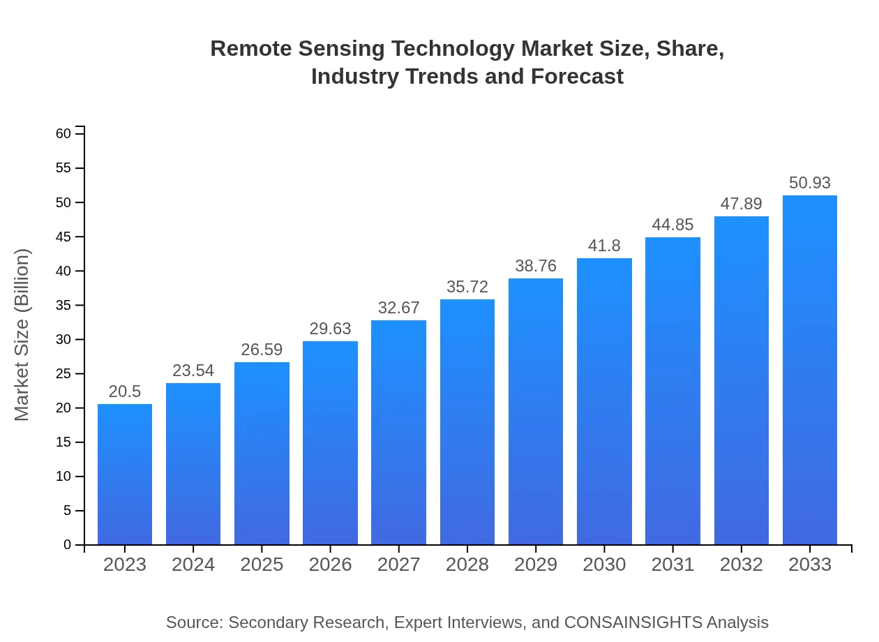
The global Remote Sensing Technology market is expected to reach a value of USD 20.5 billion in 2023, with a Compound Annual Growth Rate (CAGR) of 9.2% from 2023 to 2030. The forecast growth rate from 2023 to 2030 is estimated to be around 10.5% annually. This growth can be attributed to the increasing adoption of remote sensing technology across various industries, such as agriculture, defense, environmental monitoring, and infrastructure development.

COVID-19 Impact on the Remote Sensing Technology Market

The COVID-19 pandemic has had a significant impact on the Remote Sensing Technology market. With the implementation of lockdowns and restrictions on movement, there has been a growing need for remote sensing technologies to monitor and track the spread of the virus. This has led to increased demand for satellite imagery, drones, and other remote sensing tools to support efforts in containing the pandemic. Additionally, the use of remote sensing technology in areas such as agriculture and infrastructure development has also seen a surge as organizations seek innovative solutions to overcome the challenges posed by the pandemic.

Remote Sensing Technology Market Dynamics

The Remote Sensing Technology market is driven by technological advancements, increasing investments in R&D, and the growing need for real-time data monitoring across various industries. The integration of artificial intelligence (AI) and machine learning (ML) algorithms with remote sensing technology has revolutionized data analysis and interpretation, providing valuable insights for decision-making. However, challenges such as data security concerns, regulatory complexities, and high implementation costs pose restraints to market growth. Opportunities arise from the adoption of remote working models, which have accelerated the demand for remote sensing solutions to support workforce management and operational efficiency.

Segments and Related Analysis of the Remote Sensing Technology Market

The Remote Sensing Technology market can be segmented based on technology, product, application, and end-user. The technology segment includes satellite-based remote sensing, aerial photography, LiDAR, and hyperspectral imaging. Products in the market range from sensors and platforms to software and services. Applications of remote sensing technology span across agriculture, defense, environmental monitoring, infrastructure development, forestry, and others. End-users of remote sensing technology include government agencies, commercial enterprises, research institutions, and non-profit organizations.

Remote Sensing Technology Market Analysis Report by Region

Asia Pacific Remote Sensing Technology Market Report

The Asia Pacific region is witnessing rapid growth in the Remote Sensing Technology market due to increasing investments in infrastructure development, agriculture, and environmental conservation. Countries such as China, India, Japan, and Australia are at the forefront of adopting remote sensing technologies for various applications. The market in Asia Pacific is projected to expand significantly in the coming years, driven by government initiatives, technological advancements, and the need for efficient resource management.

South America Remote Sensing Technology Market Report

The South America region is experiencing steady growth in the Remote Sensing Technology market, with a focus on applications in agriculture, forestry, and environmental monitoring. Countries like Brazil, Argentina, and Chile are investing in satellite imaging, drones, and LiDAR technology to enhance their capabilities in resource management and disaster response. The market in South America is expected to witness sustained growth driven by increasing awareness about the benefits of remote sensing technology.

North America Remote Sensing Technology Market Report

North America is a mature market for Remote Sensing Technology, with the presence of key players and advanced technological infrastructure. The region leads in the adoption of satellite-based remote sensing, LiDAR, and hyperspectral imaging for applications in defense, agriculture, and urban planning. The market in North America is characterized by a strong emphasis on innovation, research, and collaboration among industry stakeholders, driving continuous advancements in remote sensing technology.

Europe Remote Sensing Technology Market Report

Europe is a significant market for Remote Sensing Technology, with a focus on environmental monitoring, climate change, and sustainable development. Countries like Germany, France, and the UK are investing in remote sensing solutions to address challenges related to land use, biodiversity conservation, and disaster management. The market in Europe is characterized by stringent regulations, public-private partnerships, and the integration of remote sensing technology into various sectors to achieve socio-economic objectives.

Middle East and Africa Remote Sensing Technology Market Report

The Middle East and Africa region are witnessing increasing adoption of Remote Sensing Technology for applications in agriculture, water resource management, and urban planning. Countries like Saudi Arabia, UAE, and South Africa are leveraging satellite imagery, drones, and GIS technology to address environmental challenges and improve decision-making processes. The market in the Middle East and Africa is poised for growth, driven by government investments, infrastructure development projects, and partnerships with international organizations.

Remote Sensing Technology Market Analysis Report by Technology

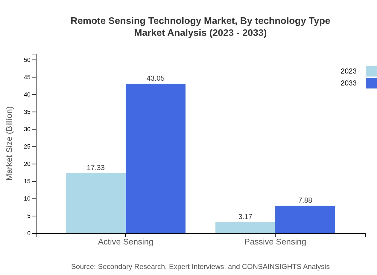
The Remote Sensing Technology market analysis by technology highlights the diverse range of remote sensing tools and solutions available in the market. Satellite-based remote sensing, aerial photography, LiDAR, and hyperspectral imaging are among the key technologies driving innovation and advancements in the field. Each technology offers unique capabilities and applications, catering to the specific needs of different industries and end-users.

Remote Sensing Technology Market Analysis Report by Product

The Remote Sensing Technology market analysis by product covers a wide range of sensors, platforms, software, and services that form the backbone of remote sensing solutions. Sensors play a crucial role in capturing data from various sources, while platforms enable the deployment of sensors for data collection. Software solutions are essential for processing, analyzing, and visualizing remote sensing data, while services encompass consulting, training, and maintenance support for remote sensing systems.

Remote Sensing Technology Market Analysis Report by Application

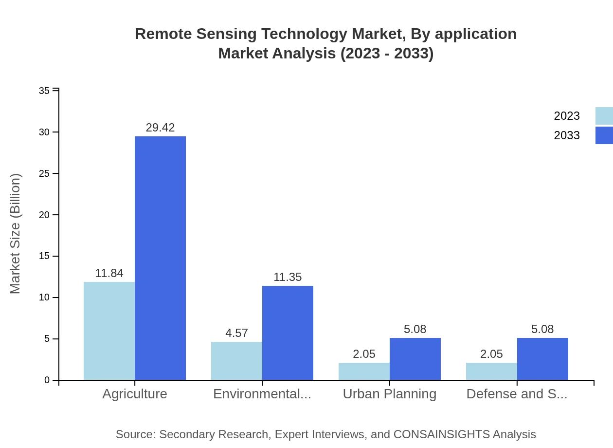
The Remote Sensing Technology market analysis by application showcases the diverse range of sectors benefiting from remote sensing solutions. Agriculture, defense, environmental monitoring, infrastructure development, forestry, and disaster management are among the key applications driving the adoption of remote sensing technology. Each application has specific requirements and challenges that remote sensing technology addresses through innovative tools and techniques.

Remote Sensing Technology Market Analysis Report by End-User

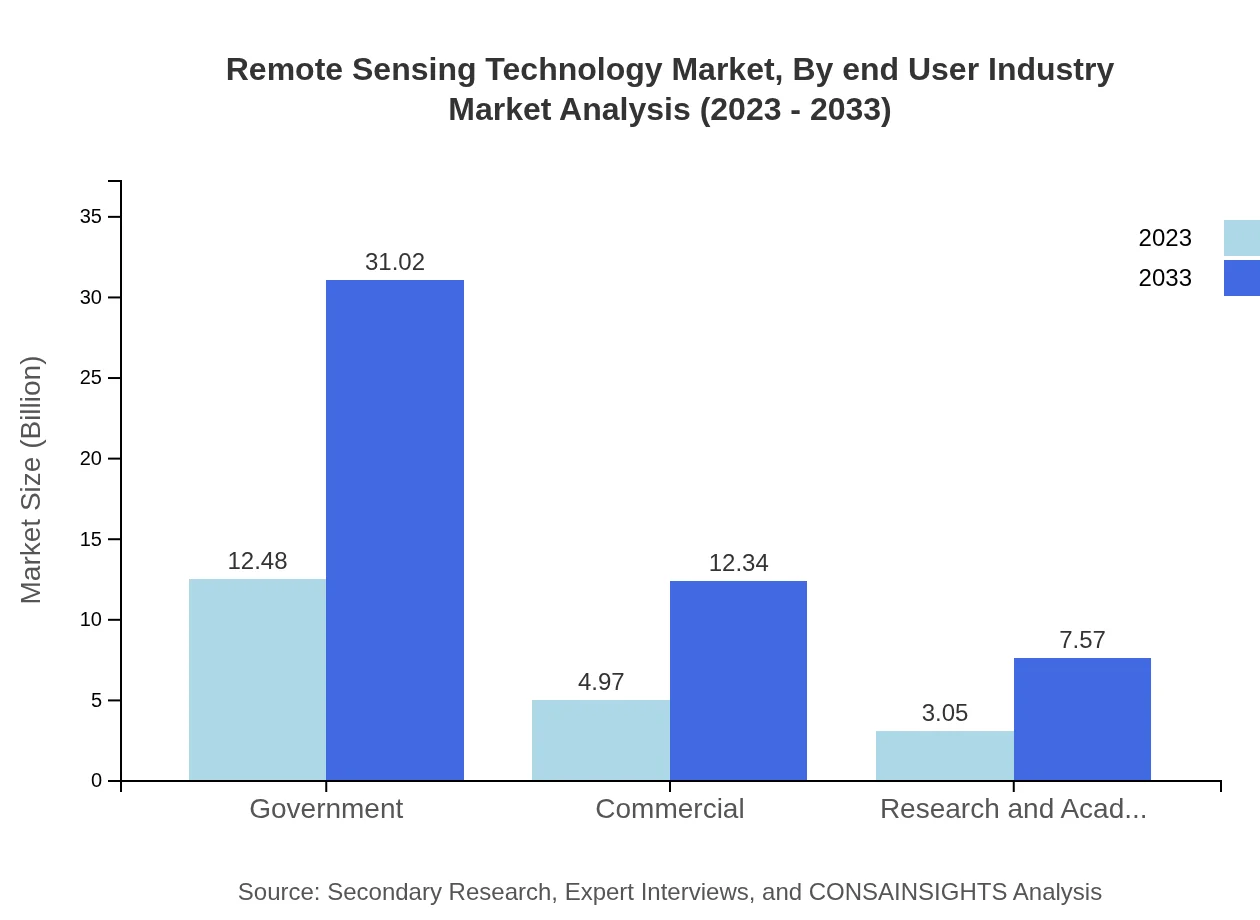
The Remote Sensing Technology market analysis by end-user focuses on the diverse range of organizations and institutions leveraging remote sensing technology. Government agencies, commercial enterprises, research institutions, and non-profit organizations are among the key end-users utilizing remote sensing solutions for various purposes. Each end-user has unique requirements and objectives that drive the demand for remote sensing technology tailored to their specific needs.

Key Growth Drivers and Key Market Players of Remote Sensing Technology Market

Key Growth Drivers:

  • Increasing demand for real-time data monitoring
  • Technological advancements in AI and ML integration
  • Rising investments in R&D for remote sensing solutions
  • Growing adoption of remote working models

Key Market Players:

  • Maxar Technologies
  • Trimble Inc.
  • Hexagon AB
  • Esri
  • BlackSky Global

Remote Sensing Technology Market Trends and Future Forecast

The Remote Sensing Technology market is witnessing several trends that are shaping its future outlook. These trends include the integration of AI and ML algorithms, the emergence of high-resolution satellite imagery, the development of compact and cost-effective sensors, and the use of drones for aerial reconnaissance. The future forecast of the Remote Sensing Technology market is optimistic, with continued innovation, strategic partnerships, and investments driving growth and expansion across various industries and regions.

Recent Happenings in the Remote Sensing Technology Market

In recent developments in the Remote Sensing Technology market:

  • Maxar Technologies launched a new satellite imaging platform for precision agriculture.
  • Trimble Inc. introduced a LiDAR scanner with advanced mapping capabilities.
  • Hexagon AB announced a strategic partnership with a leading defense contractor for aerial reconnaissance solutions.
  • Esri launched a new software suite for environmental monitoring and disaster management.
  • BlackSky Global completed a series of successful satellite launches for enhanced surveillance and intelligence gathering.

02 Research Methodology

Our research methodology entails an ideal mixture of primary and secondary initiatives. Key steps involved in the process are listed below:

  • Step 1. Data collection and Triangulation

    This stage involves gathering market data from various sources to ensure accuracy and comprehensiveness.

  • Step 2. Primary and Secondary Data Research

    Conducting in-depth research using both primary data (interviews, surveys) and secondary data (reports, articles) to gather relevant information.

  • Step 3. Data analysis

    Analyzing and interpreting the collected data to identify patterns, trends, and insights that can inform decision-making.

  • Step 4. Data sizing and forecasting

    Estimating the size of the market and forecasting future trends based on the analyzed data to guide strategic planning.

  • Step 5. Expert analysis and data verification

    Engaging subject matter experts to review and verify the accuracy and reliability of the data and findings.

  • Step 6. Data visualization

    Creating visual representations such as charts and graphs to effectively communicate the data findings to stakeholders.

  • Step 7. Reporting

    Compiling a comprehensive report that presents the research findings, insights, and recommendations in a clear and concise manner.

Data collection and Triangulation

The foundation is meticulous data gathering from multiple primary and secondary sources through interviews, surveys, industry databases, and publications. We critically triangulate these data points, cross-verifying and correlating findings to ensure comprehensiveness and accuracy.

Primary and Secondary Data Research

Our approach combines robust primary research discussion with industry experts and an exhaustive study of secondary data sources. A comprehensive analysis of published information from credible databases, journals, and market research reports complements direct interactions with industry stakeholders and key opinion leaders.

Data analysis

With a wealth of data at our disposal, our seasoned analysts meticulously examine and interpret the findings. Leveraging advanced analytical tools and techniques, we identify trends, patterns, and correlations, separating signal from noise to uncover profound insights that shed light on market realities.

Data sizing and forecasting

Armed with a profound understanding of market dynamics, our specialists employ robust statistical models and proprietary algorithms to size markets accurately. We go a step further, harnessing our predictive capabilities to forecast future trajectories, empowering clients with foresight for informed decision-making.

Expert analysis and data verification

Our research findings undergo a rigorous review by a panel of subject matter experts who lend their deep industry knowledge. This critical analysis ensures our insights are comprehensive and aligned with real-world dynamics. We also meticulously verify each data point, leaving no stone unturned in our pursuit of accuracy.

Data visualization

To unlock the true potential of our research, we employ powerful data visualization techniques. Our analysts transform complex datasets into intuitive visuals, including charts, graphs, and interactive dashboards. This approach facilitates seamless communication of key insights, enabling stakeholders to comprehend market intricacies at a glance.

Reporting

The final step is providing detailed reports that combine our in-depth analysis with practical advice. Our reports are designed to give clients a competitive edge by clearly explaining market complexities and highlighting emerging opportunities they can take advantage of.

03 Market Overview

Market Definition and Scope
Market Segmentation
Currency
Forecast
Assumptions

Market Definition and Scope

The remote sensing technology market encompasses various technologies used to collect and analyze data related to the Earth's surfaces and atmosphere. This market is critical for applications across multiple industries including agriculture, environmental monitoring, urban planning, and disaster management. In essence, remote sensing involves gathering data from satellites or aircraft to assess land use, climate conditions, and more, providing invaluable insights for decision-making.

The scope of remote sensing technology has expanded significantly with advancements in satellite, drone, and sensor technology. Initially, remote sensing was limited to the collection of images for geographical mapping; however, it has evolved to include multispectral and hyperspectral imaging techniques that can capture data across various wavelengths. Today, the market is defined not just by the hardware used, but also by the software and analytics platforms that process and visualize data.

This technology has become integral in monitoring and managing natural resources. For instance, in agriculture, remote sensing is used to assess crop health and optimize irrigation practices, contributing to food security. Similarly, environmental agencies utilize these technologies for monitoring deforestation, water quality, and air pollution, thus supporting sustainability efforts.

The market also includes service providers who deliver insights and reports based on remote sensing data, highlighting the significant role of data analytics in the sector. As industries recognize the value of data-driven decisions, the demand for comprehensive remote sensing solutions is increasing, which expands the overall market scope.

Overall, the definition and scope of remote sensing technology underscore its versatility and importance across various fields. By enabling precise monitoring and analysis, it stands pivotal in addressing some of the world's most pressing challenges, from environmental degradation to efficient resource management.

Market Segmentation

The remote sensing technology market is segmented based on various criteria including type, application, and geography. The classification by type broadly includes satellite-based and aerial-based remote sensing technologies, where satellite systems provide global coverage while aerial systems offer high-resolution data for localized studies. This distinction reflects different operational capabilities suited for diverse applications across sectors.

In terms of applications, the market encompasses sectors such as agriculture, forestry, environmental monitoring, urban planning, and disaster management. Each application area leverages remote sensing technology to gather data that informs critical decisions. For example, in agriculture, sensors can monitor soil moisture levels and crop health, helping farmers increase yields and optimize resource use. Urban planners utilize remote sensing to examine land usage patterns and forecast urban expansion.

Geographically, the market can be segmented into regions such as North America, Europe, Asia-Pacific, Latin America, and the Middle East and Africa. Each region presents unique market dynamics based on technological adoption rates, regulatory frameworks, and investment in research and development. For instance, North America exhibits a strong presence of key market players and significant investments in space technologies, whereas the Asia-Pacific region is witnessing rapid growth due to increasing applications in agriculture and urban management.

Moreover, the segmentation can also consider end-users encompassing government agencies, private enterprises, and research institutions. Government agencies often lead initiatives related to environmental monitoring, while private enterprises focus on innovative applications that drive profitability, thus contributing distinctively to market dynamics.

This multi-faceted segmentation approach allows stakeholders to identify opportunities within specific niches and tailor their strategies to align with market demands. It ensures that remote sensing technology can cater to varied customer needs, thus driving innovation and market growth.

Currency

The currency within the remote sensing technology market refers to the monetary units that market data is represented in, typically in USD for international comparisons and evaluations. Accurate financial assessments rely on a consistent currency framework, which facilitates a clearer understanding of revenue, expenditures, and profitability across different geographical markets.

Furthermore, the use of a common currency allows stakeholders, including investors and analysts, to gauge market size and growth potential effectively. When market data is reported in a single currency, it minimizes discrepancies that can arise from fluctuations in exchange rates and ensures that comparisons of financial performance over time are reliable and meaningful.

As companies engaged in remote sensing technology are often multinational, dealing in various currencies, it is crucial for financial reporting to convert local revenues and costs to a base currency. This necessitates the use of current exchange rates and accounting standards that reflect the company’s operational reality.

Additionally, currency considerations are vital during market forecasting, as exchange rate volatility can significantly impact profitability and pricing strategies. Market analysts must account for these fluctuations when projecting future revenues, ensuring that their forecasts are grounded in economic realities.

Overall, currency plays a pivotal role in shaping the remote sensing technology market, influencing how companies strategize, report financials, and plan for future growth across different regions.

Forecast

The forecast for the remote sensing technology market indicates substantial growth driven by technological advancements and increasing demand for data analysis across various sectors. Market analysts predict that the integration of artificial intelligence and machine learning into remote sensing solutions will further enhance data processing capabilities, leading to more accurate predictions and actionable insights.

Additionally, as environmental concerns gain global prominence, sectors such as agriculture and urban planning are expected to increasingly adopt remote sensing technologies to monitor changes and manage resources sustainably. This trend is likely to spur investments in both satellite and aerial remote sensing systems, thus propelling market expansion.

The forecast also suggests a growing emphasis on collaborative ecosystems where enterprises, government agencies, and research institutions will work together to harness the full potential of remote sensing technologies. Public-private partnerships can lead to innovative applications, wider scale deployments, and ultimately, greater returns on investment.

Geographically, regions that are currently underexploited, such as parts of Africa and South America, are projected to emerge as significant markets due to rising awareness and the need for improved resource management strategies. Investment in infrastructure and technology deployment are anticipated to accelerate growth in these regions.

Overall, the forecast presents a positive outlook for the remote sensing technology market, indicating a vibrant sector poised for growth, driven by innovation, collaboration, and an increasing understanding of the importance of data-driven insights in addressing global challenges.

Assumptions

Market analysis is inherently guided by a set of assumptions that frame expectations and predict trends within the remote sensing technology domain. One primary assumption is that the demand for remote sensing solutions will continue to grow, fueled by heightened awareness and government initiatives focusing on environmental sustainability and resource management.

Furthermore, stakeholders assume that technological innovations will persist, leading to more sophisticated remote sensing devices capable of capturing high-resolution data efficiently. The advent of low-cost satellite launches and advanced sensors is expected to broaden the availability and accessibility of remote sensing technology, particularly for smaller enterprises and research organizations.

There is also an assumption regarding the increasing adoption of remote sensing technology across emerging economies, where cloud-based service models can enable wider access even where traditional infrastructure might be lacking. This democratization of technology is seen as essential for global market growth.

Additionally, analysts assume that regulatory frameworks will evolve in favor of more widespread use of remote sensing, with governments recognizing the value of data accessibility for public good. This supportive environment is crucial for encouraging private sector investments in technology development.

Overall, assumptions in remote sensing technology market analysis serve as a foundation for future projections, guiding strategic decisions and helping stakeholders navigate an ever-evolving landscape with confidence.

04 Market Dynamics

Market Drivers
Market Restraints
Market Opportunities
Market Challenges

Market Drivers

The Remote Sensing Technology market is propelled by several pivotal drivers that foster growth and innovation within the sector. One of the primary drivers is the increasing demand for accurate geographical information across multiple industries. This information is essential for effective decision-making in sectors such as agriculture, forestry, and urban planning, which rely heavily on spatial data to enhance operational efficiency and resource management.

Additionally, advancements in satellite technology have significantly improved the quality and accessibility of remote sensing data. With the launch of numerous high-resolution satellites, stakeholders can now access real-time data, facilitating timely responses to environmental changes and threats. This surge in data quality is leading to greater adoption of remote sensing technologies, promoting the market's expansion.

The need for disaster management and environmental monitoring is another driving force behind the market's growth. Governments and organizations are increasingly utilizing remote sensing technologies for early warning systems, damage assessment, and rehabilitation planning following natural disasters. This capability not only aids in safeguarding lives but also minimizes economic losses and enhances sustainability practices.

Furthermore, the integration of remote sensing technology with other cutting-edge technologies such as artificial intelligence and big data analytics is transforming traditional methodologies. This combination allows for more sophisticated data processing and analytics, enabling stakeholders to gain deeper insights and improve predictive models for a variety of applications, from climate change to resource management.

There is also a growing awareness of the potential of remote sensing technologies to address global challenges such as climate change, food security, and urbanization. As governments and organizations recognize the importance of sustainable practices, investments in remote sensing solutions are expected to increase, further driving growth in the market.

Market Restraints

Despite the promising prospects, the Remote Sensing Technology market grapples with several restraints that could hinder its growth. One of the significant challenges is the high cost of satellite deployment and maintenance. The initial investment required to design, launch, and operate satellites can be prohibitively expensive, especially for smaller companies or developing nations, limiting their participation in the market.

Another restraint is the complexity associated with data acquisition and interpretation. Remote sensing generates massive volumes of data that require specialized skills and tools to analyze effectively. The shortage of trained professionals who can proficiently analyze this data poses a considerable barrier to leveraging remote sensing capabilities, which can slow down adoption rates.

Data privacy and security concerns also play a critical role in restraining market growth. As remote sensing technologies often involve the collection of sensitive information about individuals and environments, issues related to privacy, data storage, and usage can lead to public apprehension and regulatory scrutiny. Striking a balance between data accessibility and privacy protection remains a challenge for stakeholders.

Additionally, the market is facing regulatory hurdles, particularly concerning the international sharing of satellite data. Different countries have varying regulations regarding data sovereignty and export control, complicating collaboration efforts. These regulatory challenges can create delays in project implementation and hinder the overall pace of innovation in the remote sensing domain.

Lastly, environmental factors such as terrestrial obstructions or extreme weather conditions can impact the quality and accuracy of remote sensing data. Such limitations can undermine the reliability of the technology in certain scenarios, discouraging stakeholders from fully investing in remote sensing solutions.

Market Opportunities

In contrast to the obstacles, the Remote Sensing Technology market presents numerous opportunities that stakeholders can capitalize on. One of the most significant growth opportunities lies in the expansion of applications across diverse industries. As various sectors such as agriculture, urban development, and defense increasingly recognize the benefits of remote sensing, the potential for market expansion escalates. Companies can tailor their offerings to meet specific sector needs, leveraging the technology to solve unique challenges.

The advent of CubeSats and small satellite technology offers another promising opportunity. These smaller platforms are more affordable to manufacture and deploy, enabling a broader range of companies, including startups and academic institutions, to enter the market. This democratization of satellite technology enhances competition and innovation, spurring the advancement of remote sensing applications.

Developing unmanned aerial vehicles (UAVs) equipped with remote sensing capabilities represents an exciting frontier within the market. UAVs offer flexible and cost-effective solutions for data collection, enabling users to gather high-resolution imagery over areas that may be challenging to reach with traditional satellite technology. This growth in UAV adoption will likely open new doors for remote sensing applications in environmental monitoring, disaster response, and urban planning.

The integration of remote sensing with other technologies, such as Internet of Things (IoT) devices, enhances real-time data acquisition and analysis capabilities. By combining remote sensing data with IoT technologies, organizations can develop smarter solutions that respond effectively to dynamic environmental conditions, ultimately transforming how industries operate and achieve sustainability goals.

Lastly, an increasing emphasis on sustainable development presents an opportunity for remote sensing technology to show its value in monitoring environmental impacts and resource utilization. As global awareness of sustainability issues heightens, organizations are likely to invest more in remote sensing solutions to track changes over time and ensure compliance with environmental regulations.

Market Challenges

The Remote Sensing Technology market faces several formidable challenges that could impede its progress. One of the primary challenges is the persistence of data quality issues, particularly when relying on heterogeneous data sources. Ensuring the consistency and accuracy of data collected from various sensors can be arduous, leading to potential discrepancies that could affect decision-making processes in critical applications.

Additionally, the rapid pace of technological advancements poses a challenge for existing companies that must continually innovate to stay competitive. Organizations need to invest in research and development to keep up with the evolving landscape, which can be resource-intensive and may divert focus from current operations.

Competition within the remote sensing market is fierce, with numerous players vying for market share. This competitive landscape can lead to price wars and reduced profit margins, ultimately affecting the sustainability of businesses involved. Smaller entities may struggle to compete against industry giants with more extensive resources, restricting their growth potential.

Furthermore, the necessity for ongoing collaboration and partnerships between various stakeholders presents a complex challenge. Achieving effective coordination among government bodies, research institutions, and private companies can be difficult, often resulting in miscommunication and delays in project delivery.

Lastly, the integration of remote sensing technology requires a significant cultural shift within organizations. Adopting this advanced technology entails overcoming resistance to change and ensuring that all stakeholders understand its benefits, which can be a slow and challenging process. Organizations must invest in training and change management strategies to cultivate a culture that embraces innovation and technology adoption.

06 Regulatory Landscape

Overview of Regulatory Framework
Impact of Regulatory Policies on Market Growth

Overview of Regulatory Framework

The regulatory framework governing remote sensing technology is a complex amalgamation of national and international laws, treaties, and policies that aim to balance innovation with security and ethical considerations. The framework primarily revolves around how data is collected, processed, and shared. Over the last few decades, as the satellite technology has evolved, so has the need for a robust regulatory environment that addresses both the technical aspects of remote sensing and the implications of its applications.

At a national level, countries have established their own regulatory bodies to govern remote sensing activities. These agencies are responsible for issuing licenses, monitoring compliance, and ensuring that remote sensing technologies are used in accordance with national security and privacy laws. For example, in the United States, the National Oceanic and Atmospheric Administration (NOAA) oversees commercial remote sensing satellites, ensuring that data collected does not compromise national security and adheres to the policies set forth by the government.

Moreover, international treaties such as the Outer Space Treaty of 1967 establish fundamental principles governing space activities, including those related to remote sensing. This treaty emphasizes the concept that space, including the moon and other celestial bodies, shall be free for exploration and use by all countries, while still remaining subject to the region's laws and responsibilities regarding peaceful use.

The regulatory landscape is further complicated by the various technological advancements that have emerged in remote sensing, including high-resolution imagery and real-time data processing. As these technologies continue to adapt and improve, regulators find themselves challenged with boundary definitions concerning privacy, data ownership, and state sovereignty over geographic data. As such, ongoing discussions among policymakers, industry stakeholders, and legal experts are crucial to update existing regulations to reflect these changes.

In addition to national and international laws, the regulatory environment is shaped by policies aimed at fostering innovation and encouraging public-private partnerships. These policies not only promote the responsible use of remote sensing technology but also ensure that its benefits, such as enhancing disaster response and environmental monitoring, are accessible while maintaining standards of accountability and transparency.

Impact of Regulatory Policies on Market Growth

The regulatory policies surrounding remote sensing technology significantly influence market growth opportunities. Strict regulations can often inhibit the pace of innovation by imposing heavy compliance burdens on businesses, which can lead to increased operational costs and delays in product development. This can be particularly challenging for startups and smaller companies that may lack the resources to navigate complex regulatory environments.

On the contrary, a well-defined regulatory environment can serve as a catalyst for market expansion. Clear guidelines and streamlined licensing processes provide a level of predictability that encourages investment in remote sensing technologies. Stakeholders in the space industry, including satellite manufacturers, data analytics firms, and service providers, feel more inclined to invest when they understand the regulatory landscape and can anticipate changes.

The competitive landscape is also shaped by regulatory frameworks; companies that can successfully align their operations with regulatory requirements are often at a distinct advantage. For example, firms that offer unique, compliant, and reliable data services are more likely to attract partnerships with governmental and commercial entities, thus enhancing their market position and growth potential.

Furthermore, public policy can create new market opportunities by promoting the use of remote sensing technologies in sectors such as agriculture, urban planning, disaster management, and environmental monitoring. For instance, government incentives for utilizing satellite technology for land use monitoring could stimulate demand among farmers needing efficient resource management or urban planners aiming for sustainable development.

In conclusion, the regulatory policies that govern remote sensing technology have a multifaceted impact on market growth. While they can pose challenges, they also present the potential for innovation and new opportunities for economic development, ultimately determining the trajectory of the remote sensing industry in the global marketplace.

07 Impact of COVID-19 on the Artificial Intelligence Market

Short-term and Long-term Implications
Shift in Market Dynamics and Consumer Behavior

Short-term and Long-term Implications

The COVID-19 pandemic has brought unprecedented challenges to various industries, including the remote sensing technology market. In the short term, the operational disruptions caused by lockdowns led to delays in satellite launches and the processing of satellite imagery. Companies experienced staff shortages, leading to a slowdown in innovation and project execution. Many contracts were put on hold due to uncertainty, resulting in a significant revenue decline for many players in the sector.

In contrast, as countries began to adapt to the new normal, there was a growing reliance on remote sensing technology for critical applications such as monitoring environmental changes and assessing damage from natural disasters exacerbated by the pandemic. This temporary spike in demand, fueled by the global focus on public health, led to increased interest from both governmental and private entities to invest in remote sensing capabilities as a means to enhance their monitoring efforts.

As we look towards the long-term implications, the pandemic has permanently shifted the market dynamics. There is a now greater emphasis on investing in digital infrastructure and improving remote sensing capabilities to prepare for future crises. This could lead to a surge in new product development and applications of data analytics and artificial intelligence within the field. Remote sensing technology is now being viewed as an essential tool for decision making, which may result in new partnerships between governmental agencies and private firms.

Furthermore, the accelerated adoption of remote sensing technologies during the pandemic may also lead to increased competition among providers. With the increase in demand for data accessibility and real-time analysis, companies that innovate and streamline their technology will likely gain a competitive advantage. This could pave the way for emerging players to enter the market, increasing diversity and potentially lowering costs for end-users.

Lastly, the realization of remote work potential throughout the pandemic has contributed to a cultural shift within organizations. This change might lead to a reassessment of workforce distribution and investments in training for remote sensing professionals, creating a more resilient infrastructure for future challenges. Companies will likely focus on establishing robust operational frameworks that allow for flexibility and adaptability in their response to unforeseen events.

Shift in Market Dynamics and Consumer Behavior

As the pandemic reshaped numerous facets of daily life, we also witnessed significant shifts in market dynamics and consumer behavior within the remote sensing technology sphere. Consumers, both businesses and end-users, started demanding more efficient and readily available access to remote sensing data. The sudden transition to virtual solutions during the pandemic led to heightened awareness around the importance of data-driven decision-making, which increased the urgency for reliable and timely remote sensing technologies.

The rise in demand for real-time data during the pandemic saw organizations pivoting towards utilizing remote sensing for a variety of reasons, including environmental monitoring, urban planning, and agriculture management. Businesses recognized the critical role that remote sensing technology can play in enhancing their operational efficiency and ensuring business continuity, prompting them to invest in such technologies actively. This wave of innovation also translated into the development of more user-friendly interfaces and data interpretation tools, catering to a broader audience.

Consumer behavior has also shifted towards preferring platforms that provide comprehensive data analytics along with remote sensing capabilities. Clients are increasingly looking for integrated solutions that encompass not just data collection but also sophisticated analytical frameworks that help derive actionable insights. As a consequence, remote sensing technology providers are urged to innovate and enhance their offerings to meet these evolving client expectations.

The remote sensing technology market is also witnessing an increase in collaborations and partnerships between traditional companies and technology startups. This trend results from the demand for innovative solutions that can offer competitive advantages, demonstrating a shift towards a more collaborative approach within the industry. The crisis laid bare the need for agility in operations, leading to strategic alliances aimed at enhancing service delivery and closing technological gaps.

Finally, this pandemic underscored the necessity for sustainability, pressing many organizations to adopt environmentally-focused strategies. Remote sensing technology's role in such strategies became evident, as it provides essential data for climate change monitoring and assessing environmental impacts. Consequently, we anticipate a surge in applications of remote sensing in sustainability initiatives, which is likely to shape the future trajectory of the market.

08 Porter's Five Forces Analysis

Bargaining Power of Suppliers
Bargaining Power of Buyers
Threat of New Entrants
Threat of Substitutes
Competitive Rivalry

Bargaining Power of Suppliers

In the remote sensing technology market, the bargaining power of suppliers is a critical force that can significantly influence market dynamics. Suppliers in this sector often provide specialized components and essential services that are crucial for the production of remote sensing systems, such as sensors, satellites, and software solutions. As these components are not easily substitutable and require advanced technology and expertise, suppliers can exert considerable power over companies in the market.

The concentration and nature of suppliers play a vital role in this bargaining power. In remote sensing, there are a limited number of key players that manufacture high-quality sensors and related technologies, which increases their leverage. Companies relying on these suppliers may face challenges in negotiating prices or securing timely deliveries, especially when demand for advanced remote sensing technologies peaks. This can result in increased operational costs for businesses unable to source alternatives in a competitive timeframe.

Moreover, the technological expertise that suppliers possess can create a further imbalance in power. For instance, if a supplier is the only source of a groundbreaking sensor technology that enhances image resolution, their bargaining position strengthens dramatically. This situation can compel companies to form strategic partnerships with suppliers to ensure stability and continuity in sourcing, thereby potentially limiting options and increasing dependency on specific suppliers.

Additionally, the suppliers' current powers can shift depending on the innovation cycles and the emergence of new technologies. If new suppliers enter the market with innovative offerings that disrupt the traditional supply chain, the bargaining power can decrease. This ebb and flow of supplier influence can affect pricing strategies, research and development investments, and ultimately impact the competitive landscape of the remote sensing technology market.

In summary, the bargaining power of suppliers in the remote sensing technology market remains a formidable force. Companies must navigate this aspect carefully through diversification of their supplier base, technological investments, and strategic partnerships to mitigate risks associated with supplier power that can impact their operating costs and market competitiveness.

Bargaining Power of Buyers

The bargaining power of buyers in the remote sensing technology market is increasingly significant, driven by a variety of factors, including customer knowledge, competition among providers, and the diverse applications of remote sensing technologies. Buyers today are more informed than ever, often conducting extensive research before purchasing. This transparency allows them to compare products, pricing, and performance, empowering them to negotiate better terms.

Moreover, the presence of alternative technology solutions grants buyers more leverage. As new advancements emerge, businesses looking to invest in remote sensing technology can evaluate various options and select products that not only meet their specific needs but also fit their budgets. Consequently, technology providers must consistently innovate and improve their offerings to maintain their appeal and competitive edge in the market.

Another aspect of buyer power stems from the concentration of purchasing entities. If a few large organizations dominate the market for remote sensing applications, they have the ability to dictate terms. These large players may expect lower prices, better service, or additional features in exchange for their significant purchase volumes, compelling remote sensing technology suppliers to adjust their strategies, which can affect profitability.

Furthermore, the switching costs associated with changing providers often influence buyer power. In many cases, integrating new remote sensing technologies can be cumbersome and costly, which could dissuade buyers from switching to competitors despite an attractive offer. However, if the perceived benefits outweigh the costs, buyers may still choose to switch, which indicates a fluid market with a degree of volatility driven by customer preferences.

In conclusion, while the bargaining power of buyers in the remote sensing technology market is substantial, companies can manage this power by investing in customer relationships, enhancing product value, and ensuring the flexibility needed to meet evolving buyer needs effectively. As market competition intensifies, the importance of satisfying buyer demands will only become more acute, compelling organizations to evolve continuously.

Threat of New Entrants

The threat of new entrants into the remote sensing technology market is influenced by various barriers to entry, including capital requirements, technological expertise, and regulatory hurdles. Remote sensing, being a capital-intensive industry, often requires substantial investment in research and development, infrastructure, and technology. This financial barrier deters several potential entrants who may lack the necessary resources to compete effectively.

Moreover, technological expertise plays a pivotal role in establishing a foothold in this market. The development and deployment of remote sensing technologies require specialized knowledge, advanced skills, and significant experience in areas such as satellite design, atmospheric sciences, and data analysis. Therefore, new companies must either invest heavily in talent acquisition or partner with established industry experts, which can complicate market entry.

Regulatory and compliance challenges also serve as significant barriers for newcomers. The remote sensing industry is subject to stringent regulations concerning data acquisition, privacy, and environmental impact. New entrants must understand and navigate these complex regulatory frameworks, which can prolong the time to market and dissuade new competition from entering the sector.

However, certain trends, such as advancements in technology and the increasing availability of satellite imagery platforms, can potentially lower these entry barriers over time. With the rise of cloud computing and democratization of data access, we may see an influx of smaller companies offering niche remote sensing services or new business models that challenge traditional players. This dynamic can reshape the competitive landscape, but it also underscores the need for established companies to remain vigilant and responsive to emerging trends.

In summary, while the remote sensing technology market does exhibit barriers that can lessen the threat of new entrants, changes in technology and market dynamics can significantly influence this aspect. Established players must continually adapt their strategies to counter the possibilities posed by new entrants while maintaining their competitive advantages through innovation and service excellence.

Threat of Substitutes

The threat of substitutes in the remote sensing technology market presents a significant challenge, primarily due to the availability of alternative methods for data collection and analysis. Although remote sensing technologies offer unique advantages, such as the ability to gather data across vast areas and monitor environmental changes effectively, there are substitute products and services that can fulfill similar needs. For instance, ground-based survey methods and aerial surveys using drones or manned aircraft can sometimes serve as alternatives to satellite-based remote sensing.

Furthermore, advancements in other technologies, such as the Internet of Things (IoT) and environmental monitoring systems, may also pose substitution threats. IoT devices can collect localized, real-time data, allowing organizations to monitor changes in specific areas without relying solely on satellite imagery. As these technologies become more sophisticated and affordable, they may offer buyers an attractive substitute, potentially affecting their reliance on traditional remote sensing solutions.

In addition, the cost and accessibility of substitutes can significantly impact buyer decisions. If companies find that ground-based technologies or IoT solutions are cheaper or provide sufficient data quality for their particular applications, they may opt for these alternatives, leading to a decrease in demand for remote sensing technologies. This shift in consumer preference can drive remote sensing firms to innovate rapidly to retain their market share.

The differentiation of services and the added value provided by remote sensing technologies are therefore crucial in mitigating this threat. Companies that can showcase superior performance, unique characteristics, or enhanced capabilities of their offerings are better positioned to combat the competition posed by substitutes. Additionally, education and collaboration with potential clients regarding the unique benefits of remote sensing, including comprehensive data analytics and broader coverage, are essential strategies in retaining clients who may be tempted by alternatives.

In conclusion, while the remote sensing technology market faces significant threats from substitutes, the ability of established players to continuously innovate, communicate value, and perhaps integrate complementary technologies can mitigate these risks. By fostering a deeper understanding of their distinct advantages, companies in the remote sensing sector can solidify their positions against substitute solutions.

Competitive Rivalry

The competitive rivalry in the remote sensing technology market is intense, shaped by the presence of numerous firms competing for market share, technological advancements, and evolving customer demands. With established players, emerging startups, and niche providers all vying for their piece of the market, the competition drives innovation but also raises the stakes for market actors, making differentiation key for success.

One driving factor behind the heightened competitive rivalry is the rapid technological evolution within the industry. Companies must invest heavily in research and development to innovate and enhance their offerings regularly. Failure to keep pace with technological advancements can lead to market obsolescence, compelling firms to constantly evolve their product portfolios. This facet of competition creates a dynamic environment where companies either rise or fall based on their ability to adapt to new technologies.

Moreover, firms within this market compete on various fronts, including quality, pricing, and service. Some organizations attempt to create a unique selling proposition by offering superior data precision or providing added value through analytics services. Pricing is also a substantial battleground, with companies often engaging in competitive pricing strategies to attract customers. However, price undercutting can lead to pricing wars, eroding profit margins and potentially destabilizing the market.

Another contributor to competitive rivalry is the increasing number of strategic partnerships and collaborations within the industry. Companies may engage in joint ventures to leverage each other’s strengths and capabilities, thereby enhancing their competitive positioning. This trend towards collaboration suggests that while competition remains fierce, there is also a recognition of the value of partnerships as a strategy for maintaining a competitive advantage.

In conclusion, the competitive rivalry in the remote sensing technology market is robust, pushing companies to innovate continuously and refine their strategies in response to market dynamics. The blend of rapid technological advancements, diverse competitive strategies, and collaborative approaches allows for a vibrant industry landscape. Firms looking to thrive must demonstrate agility, value creation, and a clear understanding of their competitive positioning to succeed in this evolving market.

09 Key Insights and Findings

Market Overview
Technological Advancements
Market Applications
Market Trends
Future Outlook

Market Overview

The remote sensing technology market has been experiencing a significant transformation, driven by advancements in satellite technology and the increasing demand for geographic data. This growth is largely attributed to the deployment of sophisticated sensors on satellites and drones, which are capable of collecting high-resolution imagery and a plethora of environmental data. As the technology evolves, remote sensing is being adopted across a range of sectors including agriculture, urban planning, and disaster management.

According to current analyses, the global market for remote sensing technology is projected to grow at a robust CAGR (Compound Annual Growth Rate) over the next five years. The escalation in the number of satellite launches, the proliferation of data analytics tools, and the rising need for improved decision-making processes are pivotal factors contributing to this growth trajectory. Companies are now more inclined to leverage remote sensing technology for real-time monitoring and management of resources, which further stimulates market demand.

Furthermore, the increasing awareness regarding climate change and environmental monitoring is pushing governments and organizations to invest in remote sensing technologies. These technologies provide valuable insights for tracking changes in land use, atmospheric conditions, and natural resource management, thereby playing a crucial role in sustainability initiatives. This rising consciousness concerning environmental issues is becoming a substantial growth driver in the remote sensing market.

In addition, the commercial sector is quickly recognizing the benefits of remote sensing technologies. Industries such as real estate, insurance, and transportation are utilizing remote sensing data to enhance operational efficiency and minimize risks. Consequently, this burgeoning interest from the commercial segment is expected to add a significant layer of growth to the remote sensing technology market.

Overall, the remote sensing technology market is at a pivotal point of growth, with both governmental and private sector investments poised to gain momentum. This situation presents vast opportunities for technology providers and service companies that specialize in the development and application of remote sensing technologies in diverse fields.

Technological Advancements

Technological advancements are undeniably reshaping the landscape of the remote sensing technology market. With the rapid development of satellite technology, we are now witnessing an influx of high-performance satellites that offer enhanced imaging capabilities and data collection processes. Modern satellites are equipped with advanced sensors that allow for multi-spectral and hyper-spectral imaging, which significantly improve the accuracy and reliability of remote sensing data.

A key area of innovation is the integration of Artificial Intelligence (AI) and machine learning with remote sensing technologies. AI algorithms are increasingly utilized to process large volumes of remote sensing data, enabling real-time analytics and facilitating quicker decision-making processes. This convergence of AI with remote sensing not only enhances the efficiency of data processing but also improves the predictive analytics capabilities, making it a game-changer for industries ranging from agriculture to environmental science.

Moreover, the advent of small satellites and CubeSats has drastically reduced the cost barriers associated with satellite launches. These smaller, lower-cost satellites can operate in constellations, capturing frequent and reliable data that is crucial for monitoring dynamic environmental changes. The scalability and flexibility of deploying these satellites create opportunities for continuous monitoring that was previously unattainable with traditional satellite systems.

The enhancement of cloud computing technologies is another factor augmenting the capabilities of remote sensing. By leveraging cloud storage and computing power, organizations can store vast amounts of remote sensing data and utilize sophisticated processing tools to analyze this data efficiently. This connectivity allows for collaborative efforts in data interpretation and usage, thus fostering innovation and facilitating shared learning across sectors.

Finally, ongoing research into new sensor technologies promises even further advancements. Technologies such as LiDAR and Synthetic Aperture Radar (SAR) are being refined to improve spatial resolution and accuracy. This steady stream of technological upgrades ensures that the remote sensing technology market remains dynamic and innovative, constantly meeting the evolving needs of users across various industries.

Market Applications

The applications of remote sensing technology are as diverse as they are impactful. Primarily, agriculture has emerged as one of the leading sectors benefiting from remote sensing capabilities. Farmers utilize satellite imagery and drone-based remote sensing to monitor crop health, manage irrigation effectively, and optimize fertilizer application. With precision agriculture gaining traction, the ability to collect data on vegetation indices allows farmers to make informed decisions that maximize yield and minimize resource wastage.

Urban planning represents another critical domain where remote sensing plays a pivotal role. As urban areas continue to expand, city planners turn to remote sensing technologies to analyze land-use patterns, assess the effectiveness of infrastructure developments, and manage urban growth sustainably. High-resolution imagery aids planners in understanding spatial configurations and determining optimal locations for new developments while considering environmental impacts.

Disaster management has greatly benefited from advances in remote sensing technology. During natural disasters such as floods, earthquakes, or wildfires, rapid data acquisition allows for timely assessments of affected areas. Remote sensing data enables emergency response teams to identify damage, track disaster progression, and coordinate relief efforts more efficiently. The ability to visualize disaster-affected regions enhances situational awareness and facilitates better resource allocation.

Environmental monitoring is another key application of remote sensing technology. Governments and organizations are leveraging these technologies to track environmental changes, analyze deforestation rates, and monitor coastal erosions. By employing satellite images and analytical tools, researchers can gain insights into climate change impacts and assess biodiversity loss. Such applications are paramount for informing regulatory policies and conservation strategies.

Lastly, the challenge of monitoring global supply chains and logistics has led to increased interest in remote sensing technologies. Companies are employing satellite imagery to track shipping routes, monitor transportation conditions, and analyze market trends. By integrating remote sensing data into their operations, businesses can enhance their supply chain efficiency and make strategic decisions that drive production and distribution optimization.

Market Trends

Several trends are currently shaping the remote sensing technology market. The increasing push for sustainability and environmental conservation is prompting organizations to adopt remote sensing technologies that support eco-friendly practices. This trend reflects a broader global movement towards addressing climate change and promoting sustainable resource management through innovative technologies and data-driven approaches.

Another significant trend is the rise in demand for real-time data and analytics. Stakeholders from various sectors are seeking immediate insights into the status of geographical conditions and resource availability. Consequently, the capabilities of remote sensing technologies to provide timely information are becoming crucial. Organizations are now frequently utilizing remote sensing for applications that require ongoing monitoring, such as environmental inspections and agricultural assessments.

The integration of Internet of Things (IoT) devices with remote sensing technology presents considerable potentials. By connecting remote sensors with IoT platforms, data collection can be conducted in a more interconnected and automated manner. This IoT-driven approach allows for near-real-time data transmission, thus enhancing the utility of remote sensing technologies across different applications such as smart cities and precision agriculture.

Furthermore, the consolidation of firms in the remote sensing sector is also noteworthy. Mergers and acquisitions are becoming common as companies aim to strengthen their technological capabilities and expand their market reach. This consolidation trend is likely to lead to the emergence of comprehensive service providers who can offer end-to-end solutions, aligning with clients' diverse needs.

Lastly, as remote sensing becomes more mainstream, there is an increasing emphasis on developing regulations and standards to manage the ethical use of remote sensing data. Discussions on data privacy, ownership rights, and ethical data usage are taking center stage as more stakeholders recognize the significance of responsible data governance. This trend signifies a maturing market that aims to balance technological advancements with ethical considerations and social responsibility.

Future Outlook

Looking ahead, the future of the remote sensing technology market appears promising, fueled by continuous innovation and increasing adoption across various sectors. The ongoing evolution of satellite technology, especially with new missions aimed at improving resolution and data capturing capabilities, is expected to result in richer datasets that will drive deeper insights into environmental and geographical phenomena.

Moreover, as industries like agriculture and disaster management continue to adopt remote sensing solutions, we can anticipate a rise in demand for specialized data products tailored for specific sectors. Providers of remote sensing services will likely focus on developing customized solutions that address the unique challenges faced by their clientele, optimizing the application of remote sensing technologies in real-world scenarios.

The convergence of AI, cloud computing, and IoT with remote sensing showcases a future marked by greater efficiencies and data utility. Organizations that harness these technologies to provide advanced analytical tools will hold a competitive advantage in the remote sensing landscape. Additionally, advancements in AI-based algorithms could significantly improve the accuracy of data interpretation, ushering in a new era of data-driven decision-making.

We can also expect an enlargement of global partnerships and collaborations, enhancing data sharing and joint research initiatives aimed at addressing global challenges such as climate change and natural resource management. As nations seek to leverage remote sensing technology for public welfare, collaborations between governments, academia, and businesses will likely yield impactful advancements and foster innovation.

Ultimately, the remote sensing technology market is on the cusp of transformation, characterized by robust growth, evolving applications, and a wave of technological advancements. As market players adapt to these shifting paradigms and capitalize on emerging opportunities, they will play crucial roles in shaping the future of this dynamic industry.

10 Technology Overview

Satellite Imaging
Aerial Imaging
LiDAR Technology
Hyperspectral Imaging
Other Remote Sensing Technologies

Satellite Imaging

Satellite imaging is a powerful technology that allows for the observation and analysis of the Earth’s surface from space. This capability is made possible by satellites equipped with imaging sensors that capture data across various wavelengths. The satellites orbit the Earth at different altitudes and angles, enabling them to gather imagery that can be processed into detailed maps. This data is crucial for various applications, including environmental monitoring, urban planning, and disaster management.

The advancements in satellite imaging technology have led to significant improvements in image resolution and sensor capabilities. Modern satellites are capable of capturing high-resolution images that can discern objects as small as a meter or less. Furthermore, the use of multi-spectral and ultra-spectral sensors allows for the acquisition of detailed data across different spectral bands, enhancing the analysis of land cover, vegetation health, and water bodies.

One of the primary advantages of satellite imaging is its wide coverage area. Satellites can cover vast geographical regions in a single pass, making them ideal for monitoring large scale phenomena such as climate change, deforestation, and urban expansion. Moreover, the data captured can be used for time-series analysis to track changes over time, providing valuable insights for researchers and policymakers.

Satellite imagery is also increasingly being integrated with other technologies such as Geographic Information Systems (GIS), allowing for more sophisticated analyses and applications. The interplay between satellite data and GIS enables users to visualize and interpret spatial data effectively, which is crucial for informed decision-making in various sectors, including agriculture, forestry, and land use planning.

However, satellite imaging also faces challenges such as the high cost of satellite launches and the need for complex data processing frameworks. Despite these challenges, the market for satellite imaging continues to grow, driven by increasing demand for analytical data in various fields and the continuous advancements in satellite technology. This growth is expected to fuel innovation and collaboration among industry stakeholders, further enhancing the capabilities of satellite imaging.

Aerial Imaging

Aerial imaging involves capturing images from an airborne platform, such as drones, helicopters, or fixed-wing aircraft. This technology provides a flexible alternative to satellite imaging, allowing for high-resolution imagery and data collection at lower altitudes. Aerial imaging is widely used in sectors such as agriculture, construction, and environmental monitoring, providing detailed insights into land use, crop health, and infrastructure conditions.

The use of drones for aerial imaging has proliferated in recent years due to advancements in drone technology and a corresponding decrease in costs. Drones equipped with high-resolution cameras and sensors can capture detailed images and collect data efficiently over various terrains. Their ability to operate in remote or difficult-to-access areas makes them invaluable for numerous applications, from surveying landscapes to monitoring wildlife.

Aerial imaging also offers greater temporal flexibility, allowing for the collection of data before, during, and after events such as natural disasters. This capability supports rapid assessment and response initiatives, enabling authorities to analyze damages and mobilize resources more effectively. Additionally, the real-time data collection aspect of aerial imaging enhances situational awareness in emergency management.

Another advantage of aerial imaging is the ease of data integration. The imagery collected can be combined with other datasets, such as GIS data, to provide comprehensive analyses and visualizations. This integration is particularly beneficial in urban planning and construction, where aerial imagery can help assess site conditions, design layouts, and monitor progress.

Despite its advantages, aerial imaging technology also faces challenges, such as regulatory restrictions on drone flights and the need for skilled operators. Nevertheless, as technology continues to evolve and regulations adapt, the aerial imaging market is poised for growth, capitalizing on the demand for detailed and timely data in various applications.

LiDAR Technology

LiDAR (Light Detection and Ranging) technology is a state-of-the-art remote sensing method that uses laser light to measure distances and create precise three-dimensional models of the Earth's surface. This technology overcomes some limitations associated with traditional imaging methods by providing high-density point cloud data that represents the surface structure with remarkable accuracy.

LiDAR technology operates by emitting thousands of laser pulses per second and measuring the time it takes for the pulses to return after reflecting off surfaces. The resulting data allows for the creation of highly detailed topographic maps, forest canopy models, and urban infrastructure models. This detail is critical for applications in forestry management, urban planning, and geological studies.

One of the key benefits of LiDAR technology is its ability to penetrate tree canopies, revealing the ground surface below. This capability is particularly useful in forestry applications, where understanding the structure and health of forests is essential. By analyzing LiDAR data, environmental scientists can assess forest biomass, track changes in vegetation over time, and monitor wildlife habitats.

Furthermore, LiDAR is beneficial in urban environments, where it can aid in the detailed mapping of infrastructure and terrain. The high resolution of LiDAR data enhances the understanding of urban planning challenges, such as flood risk assessments and land use planning. By providing an accurate representation of terrain and buildings, LiDAR technology equips urban planners with essential information to improve decision-making.

Despite its many advantages, LiDAR technology can be expensive and complex to implement, requiring specialized equipment and skilled personnel for data acquisition and processing. However, ongoing advancements in technology are gradually reducing costs and improving accessibility, making LiDAR more widely available for various applications in remote sensing.

Hyperspectral Imaging

Hyperspectral imaging is an advanced remote sensing technology that captures a wide spectrum of light across multiple wavelengths, providing detailed information about the composition and characteristics of objects. Unlike traditional imaging methods that typically capture images in three visible wavelengths, hyperspectral imaging collects data across hundreds of bands, enabling precise analysis of various materials and substances.

This technology is particularly valuable in applications such as mineral exploration, agriculture, and environmental monitoring. By analyzing the spectral signatures of materials, hyperspectral imaging can identify mineral types, assess soil health, and monitor plant stress. This capability not only enhances decision-making in natural resource management but also helps in optimizing agricultural practices and improving yield.

Hyperspectral imaging is also instrumental in environmental assessments, allowing researchers to evaluate ecological conditions and detect changes in land cover. The ability to differentiate between materials and identify specific plant species enables more effective monitoring of habitats and ecosystems, vital for biodiversity conservation efforts.

The data obtained from hyperspectral imaging can be integrated with other technologies, such as GIS and machine learning, to further enhance analytical capabilities. This integration allows for sophisticated modeling and simulations, providing deeper insights into spatial patterns and trends. The combination of hyperspectral data with robust analytical tools facilitates improved predictions and recommendations for resource management.

While hyperspectral imaging offers numerous benefits, it also presents challenges, such as the complexity of data processing and the need for specialized expertise. The sheer volume of data collected demands advanced algorithms and processing techniques to extract meaningful information. Despite these challenges, the increasing accessibility of hyperspectral imaging technologies and the continuous development of analytical tools are expected to drive growth in this sector.

Other Remote Sensing Technologies

In addition to satellite imaging, aerial imaging, LiDAR, and hyperspectral imaging, several other remote sensing technologies contribute to the growing field of geospatial data and analytics. Technologies such as thermal imaging, radar systems, and sonar are gaining popularity for their unique capabilities in specific applications.

Thermal imaging technology measures the infrared radiation emitted by objects, allowing for the identification of thermal anomalies in structures and environments. This capability is particularly beneficial in building inspections, energy audits, and wildlife monitoring. By detecting temperature variations, thermal imaging can uncover issues such as heat leaks in buildings or the presence of animals in habitat studies.

Radar systems, including Synthetic Aperture Radar (SAR), provide the ability to capture high-resolution images regardless of weather conditions or light availability. This characteristic makes radar systems invaluable for monitoring changes in topography, tracking movements of vehicles and ships, and assessing the effects of natural disasters, such as floods and landslides.

Sonar technology utilizes sound propagation to navigate, communicate, and detect objects underwater. This method is widely used in marine applications, including seabed mapping and underwater habitat assessments. By providing detailed bathymetric data, sonar technology contributes to marine resource management and conservation efforts.

The integration of these alternative remote sensing technologies with traditional methods offers a more comprehensive understanding of the Earth's systems. As the demand for diverse data sources continues to rise, innovation in remote sensing technologies is expected to flourish, propelling advancements in both the scientific understanding and practical applications of geospatial data.

11 Remote Sensing Technology Market, By Product

12 Remote Sensing Technology Market, By Application

13 Remote Sensing Technology Market, By Deployment Mode

14 Remote Sensing Technology Market, By End-User Industry Overview

15 By Region

16 Company Profiles

Maxar Technologies - Company Profile
Planet Labs - Company Profile
DigitalGlobe - Company Profile
Airbus Defence and Space - Company Profile
Teledyne Technologies - Company Profile
Northrop Grumman - Company Profile
L3Harris Technologies - Company Profile
Sentinel Hub - Company Profile
Hexagon Geospatial - Company Profile
BlackSky - Company Profile
Skybox Imaging - Company Profile
Esri - Company Profile
Geosys - Company Profile
Earth-i - Company Profile
GeoIQ - Company Profile

17 Competitive Landscape

Market Share Analysis

Market Share Analysis

The remote sensing technology market has shown significant evolution over the last decade, characterized by the rapid development of satellite systems, aerial imagery platforms, and sensor technology enhancements. Major players in this field have carved out substantial market shares, with global dynamics that reflect both competition and collaborative efforts. As of the current analysis, companies such as DigitalGlobe, Airbus, and Hexagon hold prominent positions due to their advanced imagery capabilities and robust data processing technologies.

DigitalGlobe, known for its high-resolution satellite imagery, boasts a strong market share owing to its extensive satellite fleet and strategic partnerships with various governmental and commercial entities. It has established a reputation for delivering quality data, which is critical for applications ranging from urban planning to disaster management. Furthermore, DigitalGlobe's extensive client base underscores its pivotal role in not just providing data but also actionable insights derived from advanced analytics.

Airbus, another key player, has successfully expanded its market share by leveraging its expertise in aerospace technology to deliver innovative remote sensing solutions. Its TerraSAR-X and TanDEM-X missions exemplify how Airbus integrates synthetic aperture radar (SAR) systems to enhance environmental monitoring capabilities. By diversifying its sensor offerings and targeting industries such as agriculture, forestry, and climate science, Airbus continues to solidify its competitive edge in the remote sensing landscape.

Hexagon AB rounds out the competitive trifecta with its focus on geospatial information systems and smart digital realities. Hexagon’s remote sensing technologies are applied in a variety of sectors including transportation, defense, and urban development. Their investment in research and development has allowed them to maintain a competitive market share, driven by innovations such as real-time analytics and AI-powered data processing. This positions Hexagon not just as a data provider, but as a key player in enabling smart decision-making processes.

In summary, the remote sensing technology market exhibits a competitive environment where advancements in satellite design, sensor technology, and data analytics play crucial roles in determining market share. The interplay of innovations among these leading companies continues to drive the market forward, ensuring that remote sensing solutions become increasingly integral across various applications.

18 Investment Analysis

Investment Opportunities in Remote Sensing Market
Return on Investment (RoI) Analysis
Key Factors Influencing Investment Decisions
Investment Outlook and Future Prospects

Investment Opportunities in Remote Sensing Market

The Remote Sensing Technology Market is experiencing rapid growth due to advances in satellite technologies, increased demand for environmental monitoring, and enhanced capabilities in data processing and analytics. This growth offers various investment opportunities across multiple sectors including agriculture, forestry, urban planning, and disaster management. Investors can expect high returns as industries increasingly rely on remote sensing data for decision-making and planning.

One promising area for investment is precision agriculture, where remote sensing technologies are utilized to optimize farming practices, improve crop yields, and reduce resource consumption. By monitoring crop health and soil conditions from the sky, farmers can make informed choices about irrigation, fertilization, and pest management. This not only boosts productivity but also contributes to sustainable farming practices, which are increasingly important to consumers and regulators alike.

Another sector with significant potential is environmental monitoring. Governments and organizations are increasingly investing in remote sensing technologies to track climate change, deforestation, and biodiversity loss. This demand for accurate, real-time environmental data can present lucrative opportunities for tech companies specializing in satellite imagery and sensing technologies. Innovative solutions that provide actionable insights for environmental policy and conservation efforts are likely to attract substantial venture capital investments.

Urban planning and infrastructure development also stand to benefit from remote sensing technologies. As urban areas continue to expand, planners require detailed geographical data for effective land use, zoning, and transportation planning. Investments in technologies that facilitate the integration of remote sensing data into urban planning processes can lead to smarter cities and improved quality of life for residents.

Finally, the defense and security sector is a traditional stronghold for remote sensing investments. Nations around the globe continue to enhance their surveillance and reconnaissance capabilities through satellite and aerial imagery, creating a steady demand for advanced remote sensing technologies. Companies that provide reliable and timely remote sensing solutions for military and government applications can expect sustained growth and investment interest.

Return on Investment (RoI) Analysis

Evaluating the potential returns on investments in the remote sensing technology market necessitates a comprehensive analysis of the costs and benefits associated with various applications. The ability to generate actionable insights from vast amounts of data can position companies to create significant competitive advantages, driving higher revenues and market shares. Understanding key metrics such as the cost of deployment, operational efficiency gains, and revenue generation potential is crucial in this context.

For instance, investments in remote sensing for precision agriculture have demonstrated strong RoI. By leveraging remote data, farmers can realize savings of up to 20% in water usage and fertilizers, leading not only to cost reductions but also to higher yields. The ability to pinpoint exact areas that need attention translates into significant economic benefits over time, encouraging continued investment in this sector.

Moreover, companies involved in environmental monitoring have seen positive returns through government contracts and partnerships with NGOs. As funding for climate initiatives increases, firms that offer reliable remote monitoring solutions can secure long-term contracts, resulting in sustained revenue streams. Such agreements often lead to additional opportunities for technology enhancement, adding further value to investors.

In urban planning, the use of remote sensing can considerably reduce costs associated with traditional survey methods, while also accelerating project timelines. Municipalities adopting these technologies can see the breaking down of barriers that often stall infrastructure development. The economic and social returns from enhanced urban planning can lead to healthier communities, making these investments highly appealing to stakeholders interested in social good alongside financial returns.

Overall, the RoI in the remote sensing technology market can vary depending on the specific applications and technologies involved. However, the overarching trends indicate positive returns across multiple sectors. As the importance of data-driven decision-making continues to grow, investments in this innovative technology are poised to yield substantial long-term benefits.

Key Factors Influencing Investment Decisions

Several key factors play a crucial role in influencing investment decisions in the remote sensing technology market. Among these, technological advancements are paramount. Continuous innovation in satellite technology, image processing algorithms, and sensor capabilities is creating new opportunities that investors must evaluate carefully. Investors are likely to favor companies that demonstrate their ability to leverage cutting-edge technologies to deliver superior products and services.

Market demand is another critical consideration. The growing need for real-time data across sectors such as agriculture, urban planning, and disaster management is driving investments. Investors are keen to identify trends that indicate sustainable demand for remote sensing data and solutions. For example, as climate change becomes an increasingly urgent issue, the demand for data that informs policy decisions and environmental monitoring is likely to rise.

Regulatory frameworks also significantly affect investment decisions. Compliance with local and international regulations can influence market entry strategies for technology firms. Investors are interested in companies that are adept at navigating these regulations while still delivering innovative solutions. The potential for government funding and support for remote sensing initiatives also plays into the overall investment landscape.

Risk assessment is a crucial factor influencing investment decisions. Investors typically analyze the market potential alongside risks associated with technological adoption, operational execution, and market competition. Companies that exhibit robust risk management strategies tend to attract more investor confidence, as they present a lower probability of encountering unexpected obstacles that could hinder growth.

Finally, the ability of companies to partnerships and collaboration with other stakeholders in the remote sensing ecosystem can greatly enhance investment attractiveness. Establishing alliances with tech firms, research institutions, and governmental organizations can provide firms with vital resources and networks to bolster their market position. Investors are often inclined to support companies with demonstrated capabilities in building strategic partnerships, as this can lead to increased market penetration and enhanced innovation.

Investment Outlook and Future Prospects

As we look towards the future, the investment outlook for the remote sensing technology market appears promising. The increasing integration of artificial intelligence and machine learning in analyzing remote sensing data is set to expand the capabilities of these technologies significantly. This convergence is likely to create new investment opportunities as interesting applications emerge, which can automate processes and derive deeper insights from data.

The expansion of Internet of Things (IoT) technology will also have profound implications for the remote sensing market. With more devices capable of collecting and transmitting data, the fusion of IoT and remote sensing will enable more granular analytics and foster new business models. Investors who recognize the value of this synergy are likely to capitalize on trends that blur the lines between different technology sectors.

Moreover, international collaboration on climate change initiatives will influence investment within the remote sensing market. As countries commit to sustainability goals, investments targeting solutions that provide analytical data for environmental initiatives are expected to boom. Companies that can demonstrate their commitment to these initiatives through innovation are likely to attract increased funding as they contribute to broader societal goals.

The ongoing advancements in satellite miniaturization and cost reductions are also making remote sensing solutions more accessible to a wider range of industries. This democratization of technology means that smaller businesses can engage with remote sensing data that was previously available only to large corporations. Such shifts could lead to an increase in niche markets for investors to explore, driving diversification in investment strategies.

In conclusion, the investment outlook for the remote sensing technology market is rooted in continuous innovation, growing demand across a variety of sectors, and the potential for integrating emerging technologies. As investors navigate these dynamics, they are positioned to make informed decisions that align with both the current landscape and future potential within this exciting field.

19 Strategic Recommendations

Market Entry Strategies for New Players
Expansion and Diversification Strategies for Existing Players
Product Development and Innovation Strategies
Collaborative Strategies and Partnerships
Marketing and Branding Strategies
Customer Retention and Relationship Management Strategies

Market Entry Strategies for New Players

Entering the remote sensing technology market requires a multifaceted approach, as this sector is not only technically complex but also highly competitive. New players should begin with a comprehensive market analysis to identify gaps and opportunities that existing players may have overlooked. It is essential to focus on specific niches within the remote sensing market, such as agricultural monitoring, disaster management, or urban planning, to differentiate from competitors and establish a foothold.

Additionally, potential entrants should consider leveraging advanced technologies such as artificial intelligence (AI) and machine learning (ML) to enhance their remote sensing capabilities. Developing proprietary algorithms that can process and analyze data more efficiently will enable new players to offer unique products and services that stand out in the crowded marketplace.

Moreover, strategic partnerships with established entities in related fields can facilitate market entry. Collaborating with universities, research institutions, or even other tech companies can provide newcomers with access to vital resources, including data algorithms, technical expertise, and industry knowledge. These alliances can also help in reducing initial operational costs and risks associated with entering a new market.

To complement these strategies, it is crucial for new players to build a strong online presence. This includes a user-friendly website that showcases their unique value propositions, technical capabilities, and case studies, which can help instill confidence in potential customers. Additionally, active social media engagement can enhance visibility and create awareness among target client segments.

Lastly, exploring government contracts and grants focused on technology development can provide crucial funding and exposure. Many governments are increasingly investing in remote sensing technologies for various applications; thus, aligning product offerings with public sector needs can pave the way for successful market entry.

Expansion and Diversification Strategies for Existing Players

For existing players in the remote sensing technology market, continuous growth is essential for maintaining a competitive edge. One of the most effective strategies is market expansion into emerging economies where there is a growing demand for remote sensing solutions across various sectors, including agriculture, environmental monitoring, and urban development. By establishing operations in regions with significant technological adoption, companies can capitalize on new market potential while diversifying their revenue streams.

In addition, expanding product offerings to include complementary solutions is a viable strategy. Existing players can explore adjacent markets such as geospatial analysis or data visualization. By bundling remote sensing products with these services, companies can provide a comprehensive package to their clients, thereby enhancing customer satisfaction and loyalty while increasing overall sales.

Investing in R&D plays a pivotal role in driving innovation and maintaining relevance in a rapidly evolving technological landscape. Diversification through innovative technologies, such as the integration of drones with traditional remote sensing methods, can yield more precise and versatile solutions. Companies should encourage a culture of innovation, ensuring that they continuously explore state-of-the-art technologies and methodologies to respond proactively to market demands.

Furthermore, taking a proactive approach towards mergers and acquisitions can effectively bolster growth. By acquiring smaller tech firms with synergistic capabilities or new technologies, established players can quickly integrate new products into their offerings and gain a competitive advantage. Such strategic acquisitions can also help in entering new verticals and niches with minimal resistance.

Lastly, focusing on fostering strong industry relationships and building strategic alliances can enhance growth opportunities. Collaborating with technology providers, government stakeholders, and industry associations not only aids in maximizing resource utilization but also helps in navigating regulatory environments more efficiently, which is crucial for seamless expansion and diversification.

Product Development and Innovation Strategies

To stand out in the remote sensing technology market, continuous product development and innovation should be at the forefront of any strategy. Companies must actively engage their R&D departments in exploring new technologies that can enhance the functionality and accuracy of their remote sensing tools. Investments in the development of advanced sensors, improved data processing algorithms, and state-of-the-art imaging techniques will ensure that they remain competitive in a rapidly evolving landscape.

Furthermore, user feedback should play a significant role in guiding product development efforts. By consistently soliciting input from end-users and pilot testing new products, companies can better align their offerings with market needs. This user-centric approach not only helps in refining product features but also fosters brand loyalty as customers feel their needs are being prioritized.

Additionally, incorporating sustainability into product development can create a distinct advantage. As environmental concerns become more pressing, developing remote sensing solutions that minimize energy consumption and enhance data collection efficiency can attract environmentally-conscious clients. Demonstrating a commitment to sustainable practices can enhance brand image and open pathways to new customer segments.

Moreover, integrating artificial intelligence and machine learning technologies into remote sensing products can significantly enhance analysis capabilities. By leveraging big data analytics, products can offer deeper insights and predictive analytics, creating immense value for clients across various domains such as urban planning or climate monitoring. Companies should invest in developing such smart solutions that incorporate these intelligent technologies.

Lastly, fostering an agile culture within product teams benefits quick adaptations to changing technologies and market demands. Adopting agile methodologies can enhance collaboration, creativity, and speed, enabling teams to iterate quickly on product features and capabilities, thus staying ahead of the competition in the innovation race.

Collaborative Strategies and Partnerships

Within the remote sensing technology market, strategic collaborations and partnerships can significantly enhance a company’s competitive position. By establishing partnerships with specialists in different areas—be it data analytics firms, software developers, or policy organizations—companies can create synergies that enhance their product offerings and reach new customer bases. Such collaborations can lead to more robust solutions that combine the strengths of each partner.

Moreover, collaboration with academic institutions can foster innovation and research initiatives. Tap into academic resources such as advanced modeling techniques or novel sensor technologies can provide companies with fresh perspectives and cutting-edge methodologies. Joint research projects and internship programs can spur innovation and bring emerging talent into the organization.

Cross-industry partnerships are also an effective strategy to broaden market reach. For instance, collaborating with telecommunications firms can enhance data transfer capabilities, leading to improved data collection and transmission in remote areas. Such collaborative efforts can bolster product efficacy while expanding market potential.

In addition to partnerships, participating in consortia or industry alliances can create a strong presence in the market. By joining forces with other companies, stakeholders can advocate for pain points, share best practices, and streamline standards within the remote sensing industry. This collective approach can shape the industry landscape, making it easier to navigate regulatory hurdles and promote new innovations.

Lastly, leveraging partnerships for joint marketing and distribution can create greater customer awareness. Co-branding initiatives or shared marketing strategies can enhance visibility for both parties while enabling them to reach wider audiences. This collaborative marketing approach can significantly reduce costs while amplifying the impact and reach of promotional activities.

Marketing and Branding Strategies

For companies in the remote sensing technology market, effective marketing and branding strategies are essential for establishing recognition and preference among target customer segments. A well-defined branding strategy that articulates the unique value propositions of the company’s products must be created. This can involve crafting a compelling narrative around the brand that highlights its commitment to innovation, sustainability, and customer satisfaction.

Digital marketing plays a crucial role in reaching a broader audience. Establishing a strong online presence through a data-driven digital marketing strategy that includes SEO, content marketing, and targeted advertising can significantly enhance brand visibility. Engaging in webinars, online campaigns, or interactive infographics showcasing remote sensing applications can educate potential customers while positioning the brand as a thought leader in the industry.

Moreover, leveraging social media platforms to connect directly with potential clients is essential. Companies should actively engage with their audience by sharing updates on technological advancements, case studies, and insights into the impact of their products on various sectors. This organic interaction can build community, enhance brand loyalty, and capture leads more effectively.

Another critical aspect is the development of targeted marketing campaigns specific to different customer segments. Identifying and understanding the unique needs and pain points of each segment will allow companies to tailor their messaging and offers accordingly. Customizing promotional efforts can lead to higher engagement rates and greater conversion potential.

Lastly, participating in industry trade shows, conferences, and workshops increases brand exposure while offering opportunities for potential partnerships. These events provide invaluable platforms for networking, showcasing innovations, and establishing a physical presence in the industry, which can translate into increased credibility and customer trust.

Customer Retention and Relationship Management Strategies

In the remote sensing technology market, customer retention is just as critical as gaining new clients. Establishing robust customer relationship management (CRM) strategies ensures that companies not only retain their existing clientele but also foster loyalty. One effective approach is to implement regular follow-ups and personalized engagement with customers to gauge their satisfaction and identify areas for improvement.

Moreover, investing in customer training and support resources can significantly enhance the overall customer experience. Providing webinars, tutorials, and user manuals that clearly explain how to maximize the value of remote sensing products can empower customers, making them more likely to remain loyal. A well-informed customer base that sees tangible results will contribute positively to long-term retention rates.

Additionally, soliciting and acting upon customer feedback plays a pivotal role in strengthening relationships. Creating mechanisms for customers to share their insights and suggestions allows companies to adapt their offerings and demonstrate responsiveness to their needs. Regularly conducting surveys and actively addressing concerns can cultivate a strong relationship built on transparency and trust.

Furthermore, establishing loyalty programs or incentives for long-term customers can provide additional motivation for continued engagement. Providing discounts, exclusive access to new features, or complimentary services for repeat clients creates a sense of appreciation and value. Such initiatives can enhance customer satisfaction and build stronger brand loyalty over time.

Lastly, utilizing data analytics for customer insights can help tailor interaction strategies. By analyzing usage patterns, preferences, and engagement levels, companies can develop targeted retention campaigns that meet their customers’ specific needs. Employing a data-driven approach ensures that retention efforts are not only effective but also efficient, allowing for resource optimization while maximizing customer value.

Remote Sensing Technology Market Report Market FAQs

1. What is the market size of the Remote Sensing Technology?

The market size of the Remote Sensing Technology industry was valued at $17.5 billion in 2020 and is projected to reach $25.6 billion by 2025, growing at a CAGR of 7.9% during the forecast period.

2. What are the key market players or companies in the Remote Sensing Technology industry?

Some of the key market players in the Remote Sensing Technology industry include Airbus Group, Thales Group, Lockheed Martin Corporation, Raytheon Company, and Maxar Technologies, among others.

3. What are the primary factors driving the growth in the Remote Sensing Technology industry?

The primary factors driving the growth in the Remote Sensing Technology industry include the increasing demand for Earth observation data for various applications such as agriculture, urban planning, disaster management, and environmental monitoring. Technological advancements in sensors, data analytics, and artificial intelligence are also driving the growth of the industry.

4. Which region is identified as the fastest-growing in the Remote Sensing Technology?

Asia Pacific is identified as the fastest-growing region in the Remote Sensing Technology industry, driven by investments in satellite technology, increasing government initiatives for Earth observation, and the growing adoption of remote sensing technology in sectors such as agriculture, forestry, and infrastructure development.

5. Does ConsaInsights provide customized market report data for the Remote Sensing Technology industry?

Yes, ConsaInsights provides customized market report data for the Remote Sensing Technology industry, tailored to meet the specific requirements and insights needed by clients. Our reports offer detailed analysis, market trends, competitive landscape, and strategic recommendations for businesses operating in the industry.

6. What deliverables can I expect from this Remote Sensing Technology market research report?

The Remote Sensing Technology market research report from ConsaInsights includes a comprehensive analysis of market trends, growth drivers, challenges, opportunities, market segmentation, competitive landscape, key player profiles, market sizing and forecasting, and strategic recommendations for businesses looking to enter or expand their presence in the market.